IMAGES TAKEN NEAR TO
Clarence Road, HINCKLEY, LE10 1BL
Introduction
This page details the photographs taken nearby to Clarence Road, LE10 1BL by members of the Geograph project.
The Geograph project started in 2005 with the aim of publishing, organising and preserving representative images for every square kilometre of Great Britain, Ireland and the Isle of Man.

There are currently over 7.5m images from over14,400 individuals and you can help contribute to the project by visiting https://www.geograph.org.uk
Image Map (Loading...)


Getting Data...Please wait
Leaflet Map data © OpenStreetMap
Images are licensed for reuse under creativecommons.org/licenses/by-sa/2.0
Notes
- Clicking on the map will re-center to the selected point.
- The higher the marker number, the further away the image location is from the centre of the postcode.
Image Listing (9 Images Found)
Images are licensed for reuse under creativecommons.org/licenses/by-sa/2.0
Image
Details
Distance
2
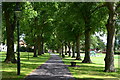
Path between avenue of trees in Queen's Park
Image: © David Martin
Taken: 30 Jul 2017
0.15 miles

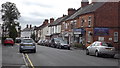
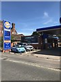
7
Convenience store
A corner shop in suburban Hinckley.
Image: © Peter Mackenzie
Taken: 2 Jan 2018
0.22 miles
8
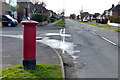
Postbox on Brookside in Burbage
On the corner of Hillrise.
Image: © Mat Fascione
Taken: 2 Jan 2015
0.24 miles