IMAGES TAKEN NEAR TO
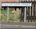
William Iliffe Street, HINCKLEY, LE10 0LY
Introduction
This page details the photographs taken nearby to William Iliffe Street, LE10 0LY by members of the Geograph project.
The Geograph project started in 2005 with the aim of publishing, organising and preserving representative images for every square kilometre of Great Britain, Ireland and the Isle of Man.

There are currently over 7.5m images from over14,400 individuals and you can help contribute to the project by visiting https://www.geograph.org.uk
Image Map
Images are licensed for reuse under creativecommons.org/licenses/by-sa/2.0
Notes
- Clicking on the map will re-center to the selected point.
- The higher the marker number, the further away the image location is from the centre of the postcode.
Image Listing (45 Images Found)
Images are licensed for reuse under creativecommons.org/licenses/by-sa/2.0
Image
Details
Distance
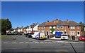
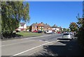
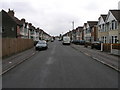
3
Houses on corner of Strathmore Road/William Iliffe Street junction
Image: © Andrew Tatlow
Taken: 27 Sep 2018
0.07 miles
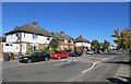
5
Strathmore Road/William Iliffe Street junction
Image: © Andrew Tatlow
Taken: 27 Sep 2018
0.07 miles
6
Houses on Strathmore Road eastwards from William Iliffe Street
Image: © Andrew Tatlow
Taken: 27 Sep 2018
0.08 miles
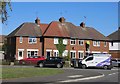
9
Beaumont Road
An example of circa 1950s? semi-detached housing.
Image: © Michael Patterson
Taken: 27 Jun 2006
0.10 miles
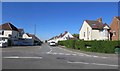
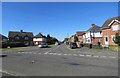
10
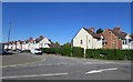
Beaumont Avenue/Strathmore Road junction
Image: © Andrew Tatlow
Taken: 27 Sep 2018
0.10 miles