IMAGES TAKEN NEAR TO
Trinity Vicarage Road, HINCKLEY, LE10 0BX
Introduction
This page details the photographs taken nearby to Trinity Vicarage Road, LE10 0BX by members of the Geograph project.
The Geograph project started in 2005 with the aim of publishing, organising and preserving representative images for every square kilometre of Great Britain, Ireland and the Isle of Man.

There are currently over 7.5m images from over14,400 individuals and you can help contribute to the project by visiting https://www.geograph.org.uk
Image Map (Loading...)


Getting Data...Please wait
Leaflet Map data © OpenStreetMap
Images are licensed for reuse under creativecommons.org/licenses/by-sa/2.0
Notes
- Clicking on the map will re-center to the selected point.
- The higher the marker number, the further away the image location is from the centre of the postcode.
Image Listing (46 Images Found)
Images are licensed for reuse under creativecommons.org/licenses/by-sa/2.0
Image
Details
Distance
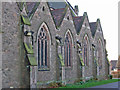
2
Milton Close view
Radio mast dominates the skyline above the town, viewed from the local area. Photo taken at the junction of Browning drive and Milton close
Image: © David Cantrill
Taken: 20 Jul 2009
0.08 miles
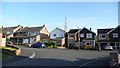
3
Milton Close
Looking from the junction of Browning drive down towards the end of the small close
Image: © David Cantrill
Taken: 20 Jul 2009
0.08 miles
4
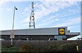
Communication tower behind Lidl, Hinckley
Image: © David Howard
Taken: 17 Aug 2023
0.09 miles
6
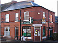
Hinckley - shops on west side of Rugby Road
For an alternative view, please see Image
Image: © Dave Bevis
Taken: 28 Dec 2013
0.18 miles
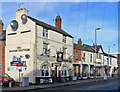
8
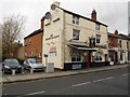
Hinckley-The Princes Feathers
Public House on Rugby Road.
Image: © Ian Rob
Taken: 9 Nov 2012
0.18 miles
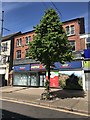
9
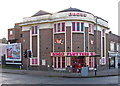
Hinckley - Bingo Club
For an alternative view, please see Image
Image: © Dave Bevis
Taken: 28 Dec 2013
0.19 miles
10
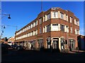
Former High Cross hosiery factory, Hinckley
Factory for making men's underwear, built 1932-3 for Atkins Brothers of Hinckley. The architects were H. L. Goddard, and Symington, Prince and Pike of Leicester. The original plan was for a building of three storeys over a ground floor with an open arcade and shops recessed behind it, occupying the whole triangular site bounded by Regent Street, George Street and Lancaster Road. In the event, only the arcaded ground floor and a first storey were built, occupying part of the site, with a second storey added in the 1950s. http://www.hinckleypastpresent.org/hinckleybuildings-r.html#regent%20street%20industrial The firm of Atkins Brothers was founded in Hinckley in 1722 by Robert Atkins, and remained under Atkins family ownership and management until 1994. It was sold the following year to Coates Viyella plc. https://www.knittingtogether.org.uk/behind-the-scenes/the-companies/atkins-of-hinckley/ The factory has since closed and has been converted into retail and office space. The photo was taken from the junction of Regent Street, onto which the long frontage faces, and Lancaster Road.
Image: © A J Paxton
Taken: 20 Oct 2018
0.19 miles