IMAGES TAKEN NEAR TO
Old Radnor, PRESTEIGNE, LD8 2UN
Introduction
This page details the photographs taken nearby to LD8 2UN by members of the Geograph project.
The Geograph project started in 2005 with the aim of publishing, organising and preserving representative images for every square kilometre of Great Britain, Ireland and the Isle of Man.

There are currently over 7.5m images from over14,400 individuals and you can help contribute to the project by visiting https://www.geograph.org.uk
Image Map
Images are licensed for reuse under creativecommons.org/licenses/by-sa/2.0
Notes
- Clicking on the map will re-center to the selected point.
- The higher the marker number, the further away the image location is from the centre of the postcode.
Image Listing (7 Images Found)
Images are licensed for reuse under creativecommons.org/licenses/by-sa/2.0
Image
Details
Distance
1
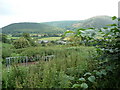
Rough grazing near Old Radnor
The countryside around Old Radnor has an untamed quality that I personally find very attractive. This field though is pretty overgrown with nettle growth at this point. It does offer nice views though.
Image: © Jeremy Bolwell
Taken: 27 Jul 2011
0.08 miles
2
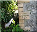
Ordnance Survey Cut Mark
This OS cut mark can be found on the roadside outbuilding at Yatt Farm. It marks a point 242.166m above mean sea level.
Image: © Adrian Dust
Taken: 22 Sep 2020
0.13 miles
3
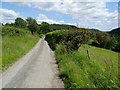
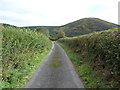
Country road at Burlingjobb
Narrow country road above Burlingjobb.
Image: © Philip Halling
Taken: 22 Jun 2019
0.14 miles
4
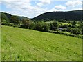
Farmland at Burlingjobb
Farmland at Burlingjobb in a valley in the Radnor Hills of the Welsh borders
Image: © Philip Halling
Taken: 22 Jun 2019
0.16 miles
5
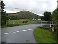
Part of Burlingjobb looking south to Hanter Hill
A heavy horse crosses his paddock.
Image: © Jeremy Bolwell
Taken: 5 Sep 2011
0.16 miles
6
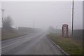
B4594, Burlingjob
Deep in quarry country, under a temperature inversion.
Image: © Richard Webb
Taken: 28 Dec 2016
0.17 miles
7
Part of Hanter Lane
With Hanter Hill behind.
Image: © Jeremy Bolwell
Taken: 5 Sep 2011
0.21 miles