IMAGES TAKEN NEAR TO
New Radnor, PRESTEIGNE, LD8 2TH
Introduction
This page details the photographs taken nearby to LD8 2TH by members of the Geograph project.
The Geograph project started in 2005 with the aim of publishing, organising and preserving representative images for every square kilometre of Great Britain, Ireland and the Isle of Man.

There are currently over 7.5m images from over14,400 individuals and you can help contribute to the project by visiting https://www.geograph.org.uk
Image Map
Images are licensed for reuse under creativecommons.org/licenses/by-sa/2.0
Notes
- Clicking on the map will re-center to the selected point.
- The higher the marker number, the further away the image location is from the centre of the postcode.
Image Listing (6 Images Found)
Images are licensed for reuse under creativecommons.org/licenses/by-sa/2.0
Image
Details
Distance
1
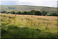
Farmland near New Radnor
A field awaiting mowing for hay or silage with the hills of the Radnor Forest in the background.
Image: © Philip Halling
Taken: 21 Jul 2012
0.08 miles
2
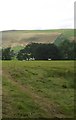
Sheep, Bank
I can remember the hill behind being white in Summer - late 1960s. It was ploughed and limed and there are still fields up there contrasting with the surviving moorland.
Image: © Richard Webb
Taken: 20 Jul 2019
0.10 miles
5
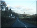
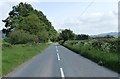
House at Upper Bank
View north-east along the B4372 as it descends into Bank.
Image: © Trevor Rickard
Taken: 24 Jan 2008
0.15 miles
6
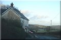
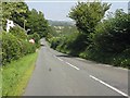
Roadside house near Bank
On the B4372 looking north-east as the road descends off Knowle Hill.
Image: © Trevor Rickard
Taken: 24 Jan 2008
0.22 miles