IMAGES TAKEN NEAR TO
Walton, PRESTEIGNE, LD8 2RE
Introduction
This page details the photographs taken nearby to LD8 2RE by members of the Geograph project.
The Geograph project started in 2005 with the aim of publishing, organising and preserving representative images for every square kilometre of Great Britain, Ireland and the Isle of Man.

There are currently over 7.5m images from over14,400 individuals and you can help contribute to the project by visiting https://www.geograph.org.uk
Image Map
Images are licensed for reuse under creativecommons.org/licenses/by-sa/2.0
Notes
- Clicking on the map will re-center to the selected point.
- The higher the marker number, the further away the image location is from the centre of the postcode.
Image Listing (18 Images Found)
Images are licensed for reuse under creativecommons.org/licenses/by-sa/2.0
Image
Details
Distance
1
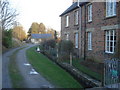
Siluria Cottages
Looking north-east along the track and small stream.
Image: © Trevor Rickard
Taken: 24 Jan 2008
0.04 miles
2
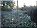
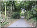
Siluria Cottages
From the lane junction looking eastwards down the entrance to Siluria Cottages. The footpath to the right leads to The Verlands.
Image: © Trevor Rickard
Taken: 24 Jan 2008
0.14 miles
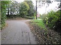
3
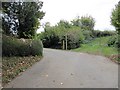
Track by the path
The road bends round to Harpton, the track leads onto the old railway.
Image: © Bill Nicholls
Taken: 18 Oct 2009
0.16 miles
4
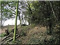
No leaves here
I wonder if Network Rail has been here as it's usually their way to stop leaves on the line, not that there is any line left. This is part of the old rail embankment at Harpton.
Image: © Bill Nicholls
Taken: 18 Oct 2009
0.16 miles
5
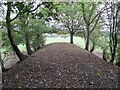
New Radnor line
The remains of the New Radnor line, the embankment flattens out after this.
Image: © Bill Nicholls
Taken: 18 Oct 2009
0.16 miles
6

Trees on the line
Nature has taken over the old rail embankment at Harpton to such an extent that one fell over and was removed leaving a hole where the roots were.
Image: © Bill Nicholls
Taken: 18 Oct 2009
0.16 miles
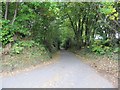
7
Bend at Harpton
A 90 degree bend at Harpton makes for a careful approach. There is also a bridleway to the right here.
Image: © Bill Nicholls
Taken: 18 Oct 2009
0.16 miles
8
Narrow bridge
You can see that this bridge would have been designed for a horse and cart by how narrow it is and the head room would have not been too high either. No wonder they removed them.
Image: © Bill Nicholls
Taken: 18 Oct 2009
0.17 miles
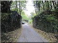
9
Road by the railway
The road from Harpton leading alongside the old rail embankment which is walled to hold the earthworks back.
Image: © Bill Nicholls
Taken: 18 Oct 2009
0.17 miles
10
Bend past the bridge
This used to be a railway bridge that carried the New Radnor line.
Image: © Bill Nicholls
Taken: 18 Oct 2009
0.17 miles