1
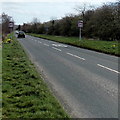
Towards Broadaxe Farm, Presteigne
Viewed across the B4355. Someone or something has caused the Give Way sign to face the wrong way. It should be facing traffic approaching the B4355 from the minor road.
Image: © Jaggery
Taken: 19 Mar 2014
0.04 miles
2
Frame Wise, Presteigne
Timber frame manufacturers in Presteigne Industrial Estate.
Image: © Jaggery
Taken: 19 Mar 2014
0.05 miles
3
Broadaxe lane
Heading northwards from the foot of Nash Wood and into Presteigne.
Image: © Trevor Rickard
Taken: 18 Feb 2008
0.06 miles
4
30 to 40 along a former railway route in Presteigne
The speed limit increases from 30mph to 40mph along the B4355 heading SE out of Presteigne.
Old maps show that this used to be a railway route, SE of Presteigne railway station,
where passenger services ceased in 1951.
Image: © Jaggery
Taken: 19 Mar 2014
0.07 miles
5
Broadaxe, Presteigne
Newtown High School, John Beddoes Campus to the left, East Radnor Leisure Centre to the right.
Image: © Oliver Dixon
Taken: 6 Aug 2021
0.08 miles
6
Presteigne Leisure Centre
View northwards at the entrance to the leisure centre. This modern leisure complex includes facilities for swimming, rugby and football.
Image: © Trevor Rickard
Taken: 18 Feb 2008
0.08 miles
7
Joe Deakins Road
Looking north-west at the entrance to the Broadaxe Business Park. This is one of the two main thoroughfares in Presteigne and acts as a bypass from the main street (not that there is ever much traffic it seems). The road was named after a prominent Town councillor following his death in 2000.
Image: © Trevor Rickard
Taken: 18 Feb 2008
0.08 miles
8
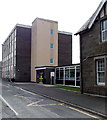
SE corner of John Beddoes School, Presteigne
Viewed across the street named Broadaxe.
Image: © Jaggery
Taken: 19 Mar 2014
0.11 miles
9
Teledyne Labtech, Presteigne
Microwave circuit board manufacturing, assembly and test centre in Broadaxe Business Park.
Image: © Jaggery
Taken: 19 Mar 2014
0.11 miles
10
John Beddoes School, Presteigne
Looking south along Broadaxe.
Image: © Jaggery
Taken: 19 Mar 2014
0.12 miles


