IMAGES TAKEN NEAR TO
Castle Road, PRESTEIGNE, LD8 2DY
Introduction
This page details the photographs taken nearby to Castle Road, LD8 2DY by members of the Geograph project.
The Geograph project started in 2005 with the aim of publishing, organising and preserving representative images for every square kilometre of Great Britain, Ireland and the Isle of Man.

There are currently over 7.5m images from over14,400 individuals and you can help contribute to the project by visiting https://www.geograph.org.uk
Image Map
Images are licensed for reuse under creativecommons.org/licenses/by-sa/2.0
Notes
- Clicking on the map will re-center to the selected point.
- The higher the marker number, the further away the image location is from the centre of the postcode.
Image Listing (509 Images Found)
Images are licensed for reuse under creativecommons.org/licenses/by-sa/2.0
Image
Details
Distance
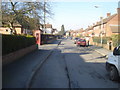
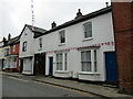
1
Police notice on lampposts in Castle Road
Many lampposts in this road have these signs. This side says "Police Notice. A court appearance could affect your life". One of the other sides says "Police Notice. Violence > Arrest > Court" and the third side shows a picture of a CCTV. Not sure I would want to see this out of my bedroom window every morning, but I assume they are at this height to prevent them being removed. As a visitor to this attractive town, I found this rather disconcerting, but I concluded that this must be the 'naughty street' and the occupants were being watched and warned.
Image: © Trevor Rickard
Taken: 18 Feb 2008
0.03 miles
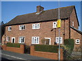
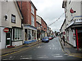
2
Presteign road junction.
Looking north-west along Joe Deakins Road with Slough Road going off to the left.
Image: © Trevor Rickard
Taken: 18 Feb 2008
0.05 miles
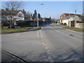
3
Castle Road
One of the 'back streets', running north towards Warden.
Image: © Trevor Rickard
Taken: 18 Feb 2008
0.06 miles
4
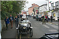
The Bull Hotel Presteigne
Presteigne with Vintage cars
Image: © pt
Taken: 15 Oct 2000
0.07 miles
5
High Street, Presteigne
The bay windowed building is Warren House https://cadwpublic-api.azurewebsites.net/reports/listedbuilding/FullReport?lang=en&id=8890 To its left is No.38 https://cadwpublic-api.azurewebsites.net/reports/listedbuilding/FullReport?lang=en&id=8891
Image: © Jonathan Thacker
Taken: 22 Aug 2022
0.07 miles
7
![Presteigne houses [50]](https://s1.geograph.org.uk/geophotos/06/96/32/6963273_13e34fd2_120x120.jpg)
Presteigne houses [50]
Formerly The Castle public house, number 40 High Street is now a private dwelling. Built in the late 17th century with later alterations. Timber framed, probably jettied at 2nd floor level, with a roughcast rendered front, all under a slate roof. The bay windows are 19th century. Listed, grade II, with details at: https://cadwpublic-api.azurewebsites.net/reports/listedbuilding/FullReport?lang=&id=8893
Presteigne is a market town, set on the south bank of the River Lugg, some 19 miles northwest of Hereford and 16 miles east of Llandrindod Wells. The Welsh/English border wraps around three sides of the town, which probably began as a small settlement around a Minster church. Formerly the county town of the historic county of Radnorshire, it remains quiet, picturesque and unspoilt.
Image: © Michael Dibb
Taken: 2 Jun 2021
0.07 miles
8
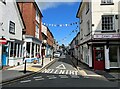
High Street, Presteigne
High Street is the main shopping street in Presteigne. It was was formerly the B4355 road until the construction of Joe Deakins Road provided an alternative route to the west avoiding the town centre.
Image: © Adrian Taylor
Taken: 29 Jul 2023
0.07 miles
9
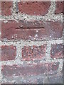
Ordnance Survey Cut Mark
This OS cut mark can be found on shop attached to No32 High Street. It marks a point 155.127m above mean sea level.
Image: © Adrian Dust
Taken: 19 Nov 2015
0.07 miles
10
![Presteigne buildings [32]](https://s0.geograph.org.uk/geophotos/06/96/32/6963264_79835f61_120x120.jpg)
Presteigne buildings [32]
Number 32 High Street is a 17th century timber framed building refronted in brick in the 18th century. The shopfront is 19th century, the roof is slate. Listed, grade II, with details at: https://cadwpublic-api.azurewebsites.net/reports/listedbuilding/FullReport?lang=&id=8889
Presteigne is a market town, set on the south bank of the River Lugg, some 19 miles northwest of Hereford and 16 miles east of Llandrindod Wells. The Welsh/English border wraps around three sides of the town, which probably began as a small settlement around a Minster church. Formerly the county town of the historic county of Radnorshire, it remains quiet, picturesque and unspoilt.
Image: © Michael Dibb
Taken: 2 Jun 2021
0.07 miles