IMAGES TAKEN NEAR TO
Green End, PRESTEIGNE, LD8 2DS
Introduction
This page details the photographs taken nearby to Green End, LD8 2DS by members of the Geograph project.
The Geograph project started in 2005 with the aim of publishing, organising and preserving representative images for every square kilometre of Great Britain, Ireland and the Isle of Man.

There are currently over 7.5m images from over14,400 individuals and you can help contribute to the project by visiting https://www.geograph.org.uk
Image Map
Images are licensed for reuse under creativecommons.org/licenses/by-sa/2.0
Notes
- Clicking on the map will re-center to the selected point.
- The higher the marker number, the further away the image location is from the centre of the postcode.
Image Listing (523 Images Found)
Images are licensed for reuse under creativecommons.org/licenses/by-sa/2.0
Image
Details
Distance
1
Presteigne information board
The board is at the southern end of Station Road Presteigne, on the corner of the B4355.
Image: © Jaggery
Taken: 19 Mar 2014
0.04 miles
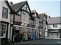
2
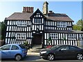
The Radnorshire Arms Hotel
The Radnorshire Arms Hotel is an impressive timber-framed building on the High Street in Presteigne. The date over the entrance is 1616 though the blue plaque on the building informs that this was the home of Sir Christopher Hutton, a favourite of Elizabeth I; she died in 1603, and he died in 1591. According to the Pevsner guide it was 'possibly built for John Bradshaw'.
Image: © Philip Halling
Taken: 21 Sep 2020
0.04 miles
3
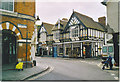
Presteigne, Black and White Houses.
A border town, once capital of Radnorshire. This building has interesting painted patterns on its upper floor.
Image: © Colin Smith
Taken: Unknown
0.05 miles
4
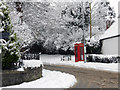
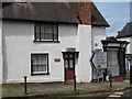
No, I think I'll use my mobile today
The phone kiosk added a little colour to an almost monochrome day.
Image: © Row17
Taken: 18 Dec 2010
0.05 miles
5
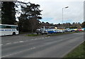
Coach and car park near the site of the former Presteigne railway station
Viewed across the B4355, here named Great Western Road. Old maps show that Presteigne railway station used to occupy this site and that the course of the B4355 behind the camera was the route of the railway to the station which was a terminus. Railway passenger services here ceased in 1951.
Image: © Jaggery
Taken: 19 Mar 2014
0.05 miles
6
Presteigne
Street corner of Station Road and the High Street.
Image: © Richard Webb
Taken: 25 Jul 2007
0.05 miles
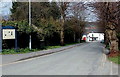
7
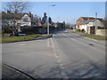
Presteign road junction.
Looking north-west along Joe Deakins Road with Slough Road going off to the left.
Image: © Trevor Rickard
Taken: 18 Feb 2008
0.06 miles
8

Green End, Presteigne
Viewed from crossroads at the junction of High Street, Broad Street and Hereford Street.
Green End is not a through road for vehicles.
Image: © Jaggery
Taken: 19 Mar 2014
0.06 miles
9
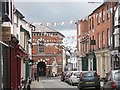
High Street
The very attractive centre of Presteigne, a town so far missed by the wreckers and supermarkets.
Image: © Richard Webb
Taken: 3 Aug 2008
0.06 miles
10
Presteigne Style
The Radnor Building in Hereford Street, Presteigne. Great Ice-cream by the way!
Image: © Gordon Cragg
Taken: 17 Apr 2003
0.06 miles