IMAGES TAKEN NEAR TO
High Street, PRESTEIGNE, LD8 2BA
Introduction
This page details the photographs taken nearby to High Street, LD8 2BA by members of the Geograph project.
The Geograph project started in 2005 with the aim of publishing, organising and preserving representative images for every square kilometre of Great Britain, Ireland and the Isle of Man.

There are currently over 7.5m images from over14,400 individuals and you can help contribute to the project by visiting https://www.geograph.org.uk
Image Map
Images are licensed for reuse under creativecommons.org/licenses/by-sa/2.0
Notes
- Clicking on the map will re-center to the selected point.
- The higher the marker number, the further away the image location is from the centre of the postcode.
Image Listing (572 Images Found)
Images are licensed for reuse under creativecommons.org/licenses/by-sa/2.0
Image
Details
Distance
1
![Presteigne buildings [25]](https://s3.geograph.org.uk/geophotos/06/96/25/6962547_ae8b2953_120x120.jpg)
Presteigne buildings [25]
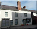
Number 10 High Street is a shop with a flat above. Built, in brick, in the 18th century with a 19th century addition towards the street. The front is roughcast with a splayed bay window and a fine shopfront, all under a slate roof. Listed, grade II, with details at: https://cadwpublic-api.azurewebsites.net/reports/listedbuilding/FullReport?lang=&id=8883
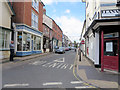
Presteigne is a market town, set on the south bank of the River Lugg, some 19 miles northwest of Hereford and 16 miles east of Llandrindod Wells. The Welsh/English border wraps around three sides of the town, which probably began as a small settlement around a Minster church. Formerly the county town of the historic county of Radnorshire, it remains quiet, picturesque and unspoilt.
Image: © Michael Dibb
Taken: 2 Jun 2021
0.00 miles
2
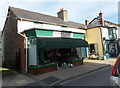
Community Transport Charity Shop, Presteigne
Viewed across High Street. The sale of donated items in the Presteigne & Norton
Community Support charity shop on the right raises funds for community transport.
Image: © Jaggery
Taken: 19 Mar 2014
0.00 miles
4
![Presteigne buildings [27]](https://s1.geograph.org.uk/geophotos/06/96/25/6962549_bb147d9d_120x120.jpg)
Presteigne buildings [27]
Number 12 High Street and Yew Tree House, number 13 High Street, is probably 17th century with later alterations. Constructed in brick, painted to number 12 and roughcast rendered to number 13, all under a slate roof. Listed, grade II, with details at: https://cadwpublic-api.azurewebsites.net/reports/listedbuilding/FullReport?lang=&id=8884
Presteigne is a market town, set on the south bank of the River Lugg, some 19 miles northwest of Hereford and 16 miles east of Llandrindod Wells. The Welsh/English border wraps around three sides of the town, which probably began as a small settlement around a Minster church. Formerly the county town of the historic county of Radnorshire, it remains quiet, picturesque and unspoilt.
Image: © Michael Dibb
Taken: 2 Jun 2021
0.01 miles
5
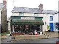
Audrey J Cole, Presteigne
High Street clothes shop.
Image: © Jaggery
Taken: 19 Mar 2014
0.01 miles
6
![Presteigne buildings [23]](https://s3.geograph.org.uk/geophotos/06/96/25/6962543_aedd36b9_120x120.jpg)
Presteigne buildings [23]
Number 8 High Street is a late 17th or early 18th century building. Timber framed with a 19th century gable to the street with a lined stucco front and shopfront, all under a slate roof. Listed, grade II, with details at: https://cadwpublic-api.azurewebsites.net/reports/listedbuilding/FullReport?lang=&id=8881
Presteigne is a market town, set on the south bank of the River Lugg, some 19 miles northwest of Hereford and 16 miles east of Llandrindod Wells. The Welsh/English border wraps around three sides of the town, which probably began as a small settlement around a Minster church. Formerly the county town of the historic county of Radnorshire, it remains quiet, picturesque and unspoilt.
Image: © Michael Dibb
Taken: 2 Jun 2021
0.01 miles
7
![Presteigne buildings [24]](https://s1.geograph.org.uk/geophotos/06/96/25/6962545_898e9148_120x120.jpg)
Presteigne buildings [24]
Number 9 High Street is a 17th century timber framed building with a later roughcast front and double projecting shopfront, all under a slate roof. Listed, grade II, with details at: https://cadwpublic-api.azurewebsites.net/reports/listedbuilding/FullReport?lang=&id=8882
Presteigne is a market town, set on the south bank of the River Lugg, some 19 miles northwest of Hereford and 16 miles east of Llandrindod Wells. The Welsh/English border wraps around three sides of the town, which probably began as a small settlement around a Minster church. Formerly the county town of the historic county of Radnorshire, it remains quiet, picturesque and unspoilt.
Image: © Michael Dibb
Taken: 2 Jun 2021
0.01 miles
8
![Presteigne buildings [26]](https://s0.geograph.org.uk/geophotos/06/96/25/6962548_1777dbd4_120x120.jpg)
Presteigne buildings [26]
Number 11 High Street is an 18th century building of rubble stone with a later projecting shopfront.
Presteigne is a market town, set on the south bank of the River Lugg, some 19 miles northwest of Hereford and 16 miles east of Llandrindod Wells. The Welsh/English border wraps around three sides of the town, which probably began as a small settlement around a Minster church. Formerly the county town of the historic county of Radnorshire, it remains quiet, picturesque and unspoilt.
Image: © Michael Dibb
Taken: 2 Jun 2021
0.01 miles
10
![Presteigne houses [51]](https://s1.geograph.org.uk/geophotos/06/96/32/6963289_c826c22d_120x120.jpg)
Presteigne houses [51]
Belmont House, number 43 High Street has 17th century origins with late 18th or early 19th century extensions. Timber framed, refronted in stuccoed brick under a slate roof. Listed, grade II, with details at: https://cadwpublic-api.azurewebsites.net/reports/listedbuilding/FullReport?lang=&id=8895
Presteigne is a market town, set on the south bank of the River Lugg, some 19 miles northwest of Hereford and 16 miles east of Llandrindod Wells. The Welsh/English border wraps around three sides of the town, which probably began as a small settlement around a Minster church. Formerly the county town of the historic county of Radnorshire, it remains quiet, picturesque and unspoilt.
Image: © Michael Dibb
Taken: 2 Jun 2021
0.01 miles