IMAGES TAKEN NEAR TO
Beulah, LLANWRTYD WELLS, LD5 4YG
Introduction
This page details the photographs taken nearby to LD5 4YG by members of the Geograph project.
The Geograph project started in 2005 with the aim of publishing, organising and preserving representative images for every square kilometre of Great Britain, Ireland and the Isle of Man.

There are currently over 7.5m images from over14,400 individuals and you can help contribute to the project by visiting https://www.geograph.org.uk
Image Map
Images are licensed for reuse under creativecommons.org/licenses/by-sa/2.0
Notes
- Clicking on the map will re-center to the selected point.
- The higher the marker number, the further away the image location is from the centre of the postcode.
Image Listing (4 Images Found)
Images are licensed for reuse under creativecommons.org/licenses/by-sa/2.0
Image
Details
Distance
1
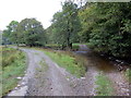
Rhyd ger Dol-berthog / Ford near Dol-berthog
Yr hen rhyd a'r trac fodern ger anhedd-dy o'r enw Dol-berthog.
The old ford and the modern track near a property known as Dol-berthog.
Image: © Alan Richards
Taken: 25 Sep 2017
0.19 miles
2
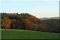
South of Gilwern
The pasture to the east and south of Gilwern is alive with pheasants, many more than the little dots seen in this picture.
Image: © Graham Horn
Taken: 25 Nov 2008
0.21 miles
3
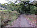
Cyffordd o lwybrau ceffyl / A junction of bridleways
Cyffordd o lwybrau ceffyl ger anhedd-dy o'r enw Dol-berthog.
A junction of bridleways near a property known as Dol-berthog (trans. hedge meadow).
Image: © Alan Richards
Taken: 25 Sep 2017
0.22 miles
4
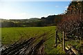
Pasture at Gilwern
The land below the road is sheep pasture, dropping gently towards the river. There is a large population of pheasants in the area as well.
Image: © Graham Horn
Taken: 25 Nov 2008
0.25 miles