IMAGES TAKEN NEAR TO
Abergwesyn, LLANWRTYD WELLS, LD5 4TP
Introduction
This page details the photographs taken nearby to LD5 4TP by members of the Geograph project.
The Geograph project started in 2005 with the aim of publishing, organising and preserving representative images for every square kilometre of Great Britain, Ireland and the Isle of Man.

There are currently over 7.5m images from over14,400 individuals and you can help contribute to the project by visiting https://www.geograph.org.uk
Image Map
Images are licensed for reuse under creativecommons.org/licenses/by-sa/2.0
Notes
- Clicking on the map will re-center to the selected point.
- The higher the marker number, the further away the image location is from the centre of the postcode.
Image Listing (28 Images Found)
Images are licensed for reuse under creativecommons.org/licenses/by-sa/2.0
Image
Details
Distance
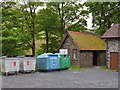
1
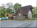
Car park, public conveniences and community hall at Abergwesyn
Also a recycling collection point. Useful.
Image: © Jeremy Bolwell
Taken: 18 Oct 2015
0.00 miles
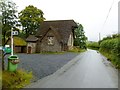
2
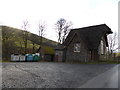
The old village school, now the community hall in Abergwesyn
An isolated rural building.
Image: © Jeremy Bolwell
Taken: 8 Dec 2013
0.00 miles
3
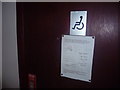
Notice on the door of the public conveniences at Abergwesyn
Thanks from me too - a great car park, clean loos, cleaned and maintained by volunteers, for the greater good. Cap doffed.
Image: © Jeremy Bolwell
Taken: 18 Oct 2015
0.00 miles
4
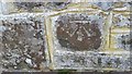
Ordnance Survey Cut Mark
This OS cut mark can be found on the front of the Hall. It marks a point 271.001m above mean sea level.
Image: © Adrian Dust
Taken: 2 Mar 2017
0.00 miles
5
Public toilets and recycling facilities
Based at the old Abergwesyn school house, which now appears to be in private hands.
Image: © Nigel Brown
Taken: 5 Jun 2013
0.00 miles
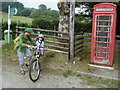
6
Abergwesyn Village Hall
With conveniences, phone box and recycling centre. http://www.powys.gov.uk/index.php?id=3246&hall_id=115&L=0
Image: © Mike Faherty
Taken: 20 Sep 2011
0.01 miles
8
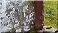
Ordnance Survey Cut Mark
This OS cut mark behind the down pipe of Bryndolou. It marks a point 271.588m above mean sea level.
Image: © Adrian Dust
Taken: 2 Mar 2017
0.08 miles
9
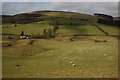
Grazing land in the Gwesyn valley
Grazing land in the Gwesyn valley at Abergwesyn viewed from the bridleway to Cefn Waun-lwyd.
Image: © Philip Halling
Taken: 22 Mar 2009
0.18 miles
10
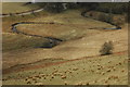
Afon Gwesyn
The meanders of Afon Gwesyn viewed from the track up Cefn Waun-lwyd.
Image: © Philip Halling
Taken: 22 Mar 2009
0.18 miles