IMAGES TAKEN NEAR TO
Llandovery Road, LLANWRTYD WELLS, LD5 4TA
Introduction
This page details the photographs taken nearby to Llandovery Road, LD5 4TA by members of the Geograph project.
The Geograph project started in 2005 with the aim of publishing, organising and preserving representative images for every square kilometre of Great Britain, Ireland and the Isle of Man.

There are currently over 7.5m images from over14,400 individuals and you can help contribute to the project by visiting https://www.geograph.org.uk
Image Map
Images are licensed for reuse under creativecommons.org/licenses/by-sa/2.0
Notes
- Clicking on the map will re-center to the selected point.
- The higher the marker number, the further away the image location is from the centre of the postcode.
Image Listing (43 Images Found)
Images are licensed for reuse under creativecommons.org/licenses/by-sa/2.0
Image
Details
Distance
1
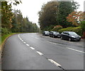
Llandovery Road, Llanwrtyd Wells
The A483 Irfon Crescent behind the camera becomes the A483 Llandovery Road ahead,
at the SW edge of Llanwrtyd Wells.
Image: © Jaggery
Taken: 30 Sep 2012
0.05 miles
2
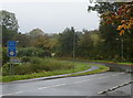
Road to Llangammarch Wells from Llanwrtyd Wells
Viewed from the corner of the A483.
A sign on the left shows that there is a low bridge, clearance 12' 6" (3.7m) 380 yards ahead.
Image: © Jaggery
Taken: 30 Sep 2012
0.10 miles
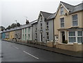
3
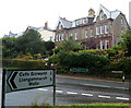
Large houses opposite the Llangammarch Wells junction, Llanwrtyd Wells
The two semi-detached houses are on the NW side of the A483 Llandovery Road.
Image: © Jaggery
Taken: 30 Sep 2012
0.10 miles
4
Janet's Hair Salon, Llanwrtyd Wells
A small name sign for Janet's Hair Salon is discreetly placed on the wall of the mottled house,
near a triangular road sign on a lamppost at centre right.
Image: © Jaggery
Taken: 30 Sep 2012
0.13 miles
5
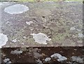
Ordnance Survey Rivet
This OS rivet can be found on the wall east side of the road. It marks a point 198.542m above mean sea level.
Image: © Adrian Dust
Taken: 2 Mar 2017
0.13 miles
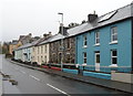
6
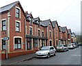
Irfon Crescent houses, Llanwrtyd Wells
Houses of the west side of Irfon Crescent viewed from the corner of Victoria Road.
Image: © Jaggery
Taken: 30 Sep 2012
0.13 miles
7
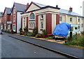
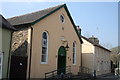
New Hall guesthouse, Llanwrtyd Wells
Located in a converted former church hall in Victoria Road.
Image: © Jaggery
Taken: 30 Sep 2012
0.17 miles
8
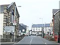
Llanwrtyd Wells
Looking northeast into the centre of the town. The rise in the road is the bridge over the river Irfon.
Image: © Nigel Davies
Taken: 22 Apr 2006
0.17 miles
10
Victoria Road houses, Llanwrtyd Wells
A view west along Victoria Road towards New Hall guesthouse. http://www.geograph.org.uk/photo/3157671
Along this part of Victoria Road, there are houses on only one side of the road.
The opposite side is the south bank of the River Irfon.
Image: © Jaggery
Taken: 30 Sep 2012
0.17 miles