
IMAGES TAKEN NEAR TO
Cefn Gorwydd, LLANGAMMARCH WELLS, LD4 4DN
Introduction
This page details the photographs taken nearby to LD4 4DN by members of the Geograph project.
The Geograph project started in 2005 with the aim of publishing, organising and preserving representative images for every square kilometre of Great Britain, Ireland and the Isle of Man.

There are currently over 7.5m images from over14,400 individuals and you can help contribute to the project by visiting https://www.geograph.org.uk
Image Map
Images are licensed for reuse under creativecommons.org/licenses/by-sa/2.0
Notes
- Clicking on the map will re-center to the selected point.
- The higher the marker number, the further away the image location is from the centre of the postcode.
Image Listing (6 Images Found)
Images are licensed for reuse under creativecommons.org/licenses/by-sa/2.0
Image
Details
Distance

2
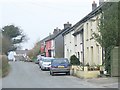
Cefn Gorwydd
The small community of Cefn Gorwydd, east of Llanwrtyd Wells.
Image: © Nigel Davies
Taken: 22 Apr 2006
0.11 miles
3

Capel Gosen Chapel, Cefngorwydd
Mynwent daclus Gosen, Addoldy'r Trefnyddion, Cefngorwydd. Adeiladwyd y capel cyntaf yn 1778 a chodwyd yr adeilad presennol yn 1830.
The well looked after burial ground of Gosen M.C. Chapel, Cefngorwydd (trans. wooded ridge). The first chapel was built in 1788 and the present meeting house was erected in 1830.
Image: © Alan Richards
Taken: 4 Aug 2012
0.13 miles
4

Ordnance Survey Cut Mark
This OS cut mark can be found on the NE face of the chapel. It marks a point 232.325m above mean sea level.
Image: © Adrian Dust
Taken: 2 Mar 2017
0.14 miles
5

Phone mast at Cefn-gorwydd
This mast lies right outside the bounds of the Coppins Holiday Home Park, one of whose caravans is also visible.
Image: © Richard Law
Taken: 15 Nov 2008
0.17 miles
