IMAGES TAKEN NEAR TO
Garthbrengy, BRECON, LD3 9TS
Introduction
This page details the photographs taken nearby to LD3 9TS by members of the Geograph project.
The Geograph project started in 2005 with the aim of publishing, organising and preserving representative images for every square kilometre of Great Britain, Ireland and the Isle of Man.

There are currently over 7.5m images from over14,400 individuals and you can help contribute to the project by visiting https://www.geograph.org.uk
Image Map
Images are licensed for reuse under creativecommons.org/licenses/by-sa/2.0
Notes
- Clicking on the map will re-center to the selected point.
- The higher the marker number, the further away the image location is from the centre of the postcode.
Image Listing (3 Images Found)
Images are licensed for reuse under creativecommons.org/licenses/by-sa/2.0
Image
Details
Distance
1
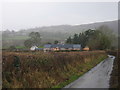
Pytingwyn Farm
Descending into the Honddu valley past Pytingwyn farm.
Image: © Dave Pinniger
Taken: 14 Jan 2008
0.01 miles
2
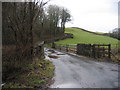
Bridge over the Honddu
Minor road bridge over the river Honddu.
Image: © Dave Pinniger
Taken: 14 Jan 2008
0.18 miles
3
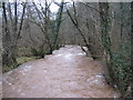
The Honddu
The river Honddu (in spate) tumbling down towards Brecon and its confluence with the River Usk.
Image: © Dave Pinniger
Taken: 14 Jan 2008
0.20 miles