IMAGES TAKEN NEAR TO
Llanddew, BRECON, LD3 9TB
Introduction
This page details the photographs taken nearby to LD3 9TB by members of the Geograph project.
The Geograph project started in 2005 with the aim of publishing, organising and preserving representative images for every square kilometre of Great Britain, Ireland and the Isle of Man.

There are currently over 7.5m images from over14,400 individuals and you can help contribute to the project by visiting https://www.geograph.org.uk
Image Map
Images are licensed for reuse under creativecommons.org/licenses/by-sa/2.0
Notes
- Clicking on the map will re-center to the selected point.
- The higher the marker number, the further away the image location is from the centre of the postcode.
Image Listing (4 Images Found)
Images are licensed for reuse under creativecommons.org/licenses/by-sa/2.0
Image
Details
Distance
1
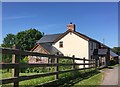
Upper Cwmdauddwr Farm
Farmhouse at Upper Cwmdauddwr Farm.
Image: © Alan Hughes
Taken: 6 Jun 2018
0.10 miles
2
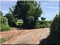
Track junction
Track junction at Upper Cwmdauddwr Farm.
Image: © Alan Hughes
Taken: 6 Jun 2018
0.12 miles
3
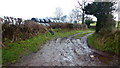
Bridleway to Penishawain
Also spelt Pen-isa'r-waen. Whichever, the track will still be muddy!
Image: © Jonathan Billinger
Taken: 29 Jan 2015
0.13 miles
4
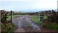
Muddy gateway, 3
Onto a field overlooking the Felinfach valley.
Image: © Jonathan Billinger
Taken: 29 Jan 2015
0.13 miles