1
Llanddew crossroads
Left for Llandefaelog (2½), ahead for Llaneglwys (6) & Talachddu (2¼), right for Troedyrharn (1).
The sign arm pointing south towards the camera shows Brecon 1¾.
All distances on the sign are in miles.
Image: © Jaggery
Taken: 18 Sep 2011
0.01 miles
2
A secular view from the lych gate, Llanddew
A view from this http://www.geograph.org.uk/photo/3339796 lych gate, looking towards houses at crossroads. http://www.geograph.org.uk/photo/3339750
Image: © Jaggery
Taken: 18 Sep 2011
0.01 miles
3
Village centre, Llanddew
The crossroads forms the centre of this village north of Brecon with castle remains.
Image: © Jonathan Billinger
Taken: 29 Jan 2015
0.02 miles
4
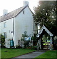
Lych gate at the entrance to the Church of St David, Llanddew
A lych gate was formerly used to shelter a coffin until the clergyman's arrival for a burial,
or pre-burial service. This one is located on the west side of the Grade I listed church. http://www.geograph.org.uk/photo/3339777
The name plate on the building on the left shows TYGWYN FARM.
Image: © Jaggery
Taken: 18 Sep 2011
0.03 miles
5
Lych Gate at St David's Church in Llanddew
Image: © Peter Robinson
Taken: 21 Jul 2012
0.03 miles
6
Bishop Gower's Well, Llanddew
A metal grill protects the well, which dates from c1340.
The well was two-sided. Villagers accessed the well from this side. The bishop and his retinue used the opposite side, inside the fortified residence known as The Bishop's Palace.
Image: © Jaggery
Taken: 18 Sep 2011
0.03 miles
7
Bishop Gower's Well, Llanddew
Dating from 1340, the well served both the village and the Bishop's Palace established here in 1175. The pump was cast in Brecon by Coppage and Son in 1908 and appears to be in working order.
Image: © Philip Pankhurst
Taken: 26 Sep 2014
0.04 miles
8
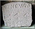
Carved stone, St David, Llanddew
Resting in the porch is this carved stone of unknown date and origin. Welsh archaeological websites are agreed that it dates from before the Conquest, so it is easily the oldest object in the village.
Image: © Philip Pankhurst
Taken: 26 Sep 2014
0.05 miles
9
The pump, Bishop Gower's well
A fine piece of Victorian engineering and still in working order.
Image: © Philip Pankhurst
Taken: 26 Sep 2014
0.05 miles
10
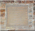
St David, Llanddew
Datestone, marking the construction of the tower in 1629.
Image: © Philip Pankhurst
Taken: 26 Sep 2014
0.05 miles


