IMAGES TAKEN NEAR TO
Cradoc Road, BRECON, LD3 9LH
Introduction
This page details the photographs taken nearby to Cradoc Road, LD3 9LH by members of the Geograph project.
The Geograph project started in 2005 with the aim of publishing, organising and preserving representative images for every square kilometre of Great Britain, Ireland and the Isle of Man.

There are currently over 7.5m images from over14,400 individuals and you can help contribute to the project by visiting https://www.geograph.org.uk
Image Map
Images are licensed for reuse under creativecommons.org/licenses/by-sa/2.0
Notes
- Clicking on the map will re-center to the selected point.
- The higher the marker number, the further away the image location is from the centre of the postcode.
Image Listing (89 Images Found)
Images are licensed for reuse under creativecommons.org/licenses/by-sa/2.0
Image
Details
Distance
1
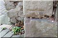
Ordnance Survey Cut Mark
This OS cut mark can be found on the wall of a house on the SW side of Cemetery Road. It marks a point 165.177m above mean sea level.
Image: © Adrian Dust
Taken: 21 Jan 2017
0.03 miles
3
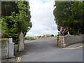
Entrance to Brecon Cemetery
The entrance is from Cradoc Road in the NW of Brecon. This is one of 17 cemeteries managed by Powys County Council's Environmental Health Service. Their responsibilities include burial bookings, maintaining grave and burial records, processing memorial applications and issuing deeds for exclusive rights to burial.
Image: © Jaggery
Taken: 4 Jun 2012
0.06 miles
4
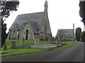
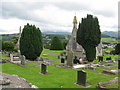
Chapels at Brecon
Identical chapels in the town cemetery
Image: © Peter Robinson
Taken: 12 Aug 2009
0.07 miles
5
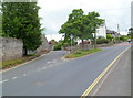
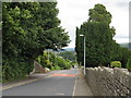
Grass triangle at a Cradoc Road junction, Brecon
A tree shades a bench in a grass triangle at the junction of Cradoc Road on the right and Fenni-fach Road on the left.
Image: © Jaggery
Taken: 4 Jun 2012
0.08 miles
7
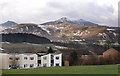
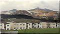
Bron-y-Crug, Pendre, 6
Social housing, 1970's style. The 1980's housing of Cradoc Close can be seen to the right.
The juxtaposition of the two housing styles and the fabulous view to the Beacons is there for all to see.
From left to right, Cribyn 795m, Pen y Fan 886m and Corn Du 873m.
Pen y Fan is the highest peak in Southern Britain.
Image: © Jonathan Billinger
Taken: 7 Mar 2018
0.09 miles
8
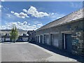
The Court
Farm conversion on Fenni Fach Road, Brecon.
Image: © Alan Hughes
Taken: 17 May 2021
0.09 miles
9
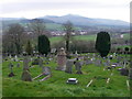
Brecon Cemetery
This cemetery off Cradoc Road enjoys a position above the Usk Valley with views out to distant Pen-y-Fan and Corn Du.
Image: © Alan Bowring
Taken: 23 Mar 2007
0.10 miles
10
Bron-y-Crug, Pendre, 5
Social housing, 1970's style.
Plus the fabulous view most of these houses enjoy.
Image: © Jonathan Billinger
Taken: 7 Mar 2018
0.10 miles