IMAGES TAKEN NEAR TO
Pendre Close, BRECON, LD3 9EH
Introduction
This page details the photographs taken nearby to Pendre Close, LD3 9EH by members of the Geograph project.
The Geograph project started in 2005 with the aim of publishing, organising and preserving representative images for every square kilometre of Great Britain, Ireland and the Isle of Man.

There are currently over 7.5m images from over14,400 individuals and you can help contribute to the project by visiting https://www.geograph.org.uk
Image Map
Images are licensed for reuse under creativecommons.org/licenses/by-sa/2.0
Notes
- Clicking on the map will re-center to the selected point.
- The higher the marker number, the further away the image location is from the centre of the postcode.
Image Listing (113 Images Found)
Images are licensed for reuse under creativecommons.org/licenses/by-sa/2.0
Image
Details
Distance
1
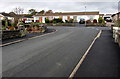
Bungalows opposite a bend in Pendre Close, Brecon
Originally, bungalow was used in English for a lightly-built house, with a veranda and one storey.
In current UK usage it is a convenient word for any one-storey dwelling.
Image: © Jaggery
Taken: 4 Nov 2018
0.01 miles
2
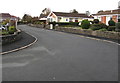
West along Pendre Close, Brecon
After a northward ascent of about 300 metres behind the camera,
the course of Pendre Close is westwards ahead.
Image: © Jaggery
Taken: 4 Nov 2018
0.02 miles
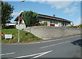
3

Bungalows in the north of Brecon
Viewed from the B4520 looking towards Pendre Close.
Image: © Jaggery
Taken: 4 Nov 2018
0.03 miles
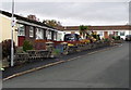
4
Road into Parc Pendre and Pendre Close, Brecon
Viewed across the B4520 Pendre.
The name sign https://www.geograph.org.uk/photo/5972017 shows Parc Pendre & Pendre Close leading to Pendre Gardens.
Image: © Jaggery
Taken: 11 Sep 2011
0.04 miles
5
Home Watch Area notice, Pendre Close, Brecon
On a lamppost on the west side of Pendre Close.
Image: © Jaggery
Taken: 4 Nov 2018
0.04 miles
6
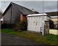
Priory Grange electricity substation, Brecon
The grey cabinet is a Western Power Distribution electricity substation.
Its identifier is PRIORY GRANGE BRECON S/S 614688
Image: © Jaggery
Taken: 4 Nov 2018
0.04 miles
7
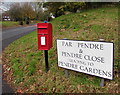
Queen Elizabeth II postbox on a north Brecon corner
Located here. https://www.geograph.org.uk/photo/3403323 In November 2018 the C is missing from PARC PENDRE on the top line of the name sign.
Image: © Jaggery
Taken: 4 Nov 2018
0.06 miles
8
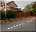
Home Watch Area notice on a Pendre lamppost, Brecon
Alongside the B4520 here named Pendre. A yellow hydrant marker sign is also on the lamppost.
Image: © Jaggery
Taken: 4 Nov 2018
0.06 miles
9
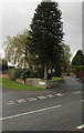
Dominant conifer on a corner in the north of Brecon
Above the corner of the B4520 Pendre and Dan-y-crug
Image: © Jaggery
Taken: 4 Nov 2018
0.06 miles
10
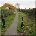
Path on the east side of Pendre Close, Brecon
Towards Beechgrove.
Image: © Jaggery
Taken: 4 Nov 2018
0.07 miles