IMAGES TAKEN NEAR TO
Defynnog, BRECON, LD3 8YH
Introduction
This page details the photographs taken nearby to LD3 8YH by members of the Geograph project.
The Geograph project started in 2005 with the aim of publishing, organising and preserving representative images for every square kilometre of Great Britain, Ireland and the Isle of Man.

There are currently over 7.5m images from over14,400 individuals and you can help contribute to the project by visiting https://www.geograph.org.uk
Image Map
Images are licensed for reuse under creativecommons.org/licenses/by-sa/2.0
Notes
- Clicking on the map will re-center to the selected point.
- The higher the marker number, the further away the image location is from the centre of the postcode.
Image Listing (22 Images Found)
Images are licensed for reuse under creativecommons.org/licenses/by-sa/2.0
Image
Details
Distance
1
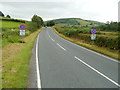
Clearway ahead SW of Defynnog
The A4067 enters a 2½ mile clearway zone (no stopping or parking) as it climbs to the SW away from Defynnog.
Image: © Jaggery
Taken: 24 Jul 2011
0.11 miles
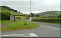
2
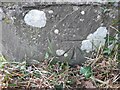
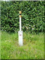
Ordnance Survey Cut Mark
This OS cut mark can be found on the gatepost NW side of the road. It marks a point 208.109m above mean sea level.
Image: © Adrian Dust
Taken: 12 Feb 2023
0.11 miles
3
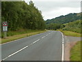
Beware of deer in the road for eight miles ahead, south of Defynnog
The sign is alongside the A4067 as it climbs away from Defynnog towards Crai.
The total number of deer I saw, in the road or elsewhere, during my descent from Crai, was zero.
Image: © Jaggery
Taken: 24 Jul 2011
0.13 miles
4
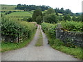
Access road to Tredustan Hall near Defynnog
Viewed from the A4067. Tredustan Hall is about 170 metres away, on the south bank of a stream, Cwm Treweryn.
Image: © Jaggery
Taken: 24 Jul 2011
0.13 miles
5
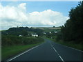
A view SW from Defynnog
Looking past a bus shelter towards hills. The road heading away from the camera is the A4067.
Image: © Jaggery
Taken: 24 Jul 2011
0.13 miles
6
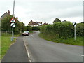
Road to Glannau Senni, Defynnog
A short connecting road leads from the A4067 to houses in Glannau Senni.
Image: © Jaggery
Taken: 24 Jul 2011
0.15 miles
7
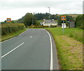
A4067 approaches Glannau Senni, Defynnog
The right turn ahead, between the bus shelter and house, is into Glannau Senni, a group of 14 houses on the outskirts of Defynnog.
Image: © Jaggery
Taken: 24 Jul 2011
0.15 miles
8
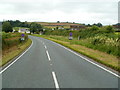
A4067 approaches Defynnog from the SW
Signs with red crosses on a blue background mark the end of a clearway (no stopping allowed).
An orange-tipped post http://www.geograph.org.uk/photo/2619806 next to the sign on the right is a pipeline indicator.
Image: © Jaggery
Taken: 24 Jul 2011
0.15 miles
10
Pipeline marker post near Defynnog
The orange-tipped post specifies the exact location of an underground 16 inch diameter pipeline. The post is alongside an end-of-clearway sign. http://www.geograph.org.uk/photo/2619791 The name on the post is Mainline Pipelines Limited.
Image: © Jaggery
Taken: 24 Jul 2011
0.16 miles