IMAGES TAKEN NEAR TO
Trecastle, BRECON, LD3 8YA
Introduction
This page details the photographs taken nearby to LD3 8YA by members of the Geograph project.
The Geograph project started in 2005 with the aim of publishing, organising and preserving representative images for every square kilometre of Great Britain, Ireland and the Isle of Man.

There are currently over 7.5m images from over14,400 individuals and you can help contribute to the project by visiting https://www.geograph.org.uk
Image Map
Images are licensed for reuse under creativecommons.org/licenses/by-sa/2.0
Notes
- Clicking on the map will re-center to the selected point.
- The higher the marker number, the further away the image location is from the centre of the postcode.
Image Listing (4 Images Found)
Images are licensed for reuse under creativecommons.org/licenses/by-sa/2.0
Image
Details
Distance
2
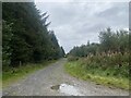
Glasfynydd Forest
Glasfynydd Forest felled area
Image: © Shaun Ferguson
Taken: 11 May 2008
0.14 miles
3
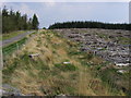
Stargazers Retreat
A distinctive feature of this area of the Brecon Beacons is the clarity of the air and absence of light pollution. Ideal for stargazing!
Image: © Alan Hughes
Taken: 28 Jan 2016
0.19 miles
4
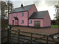
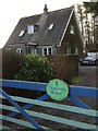
Pink House - No 7 Belfont
An unsuccessful attempt at camouflage.
Image: © Alan Hughes
Taken: 28 Jan 2016
0.21 miles