IMAGES TAKEN NEAR TO
Sennybridge, BRECON, LD3 8TY
Introduction
This page details the photographs taken nearby to LD3 8TY by members of the Geograph project.
The Geograph project started in 2005 with the aim of publishing, organising and preserving representative images for every square kilometre of Great Britain, Ireland and the Isle of Man.

There are currently over 7.5m images from over14,400 individuals and you can help contribute to the project by visiting https://www.geograph.org.uk
Image Map
Images are licensed for reuse under creativecommons.org/licenses/by-sa/2.0
Notes
- Clicking on the map will re-center to the selected point.
- The higher the marker number, the further away the image location is from the centre of the postcode.
Image Listing (3 Images Found)
Images are licensed for reuse under creativecommons.org/licenses/by-sa/2.0
Image
Details
Distance
1
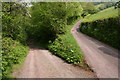
Bridleway to Gilfach (and beyond)
The track on the left is the beginning of the bridleway dropping down into the Nant Clydach valley before swinging southwest past the Gilfach farmstead and on towards the A40 trunk road.
Image: © Dave Pinniger
Taken: 23 May 2008
0.08 miles
2
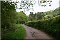
The lane to Ynys Clydach
Looking north up the Nant Clydach valley, along the lane to Ynys Clydach.
Image: © Dave Pinniger
Taken: 23 May 2008
0.11 miles
3
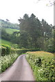
Conifer Stand
A small stand of conifers, straddling the road, heading south down the Nant Clydach valley.
Image: © Dave Pinniger
Taken: 23 May 2008
0.12 miles