IMAGES TAKEN NEAR TO
Sennybridge, BRECON, LD3 8PW
Introduction
This page details the photographs taken nearby to LD3 8PW by members of the Geograph project.
The Geograph project started in 2005 with the aim of publishing, organising and preserving representative images for every square kilometre of Great Britain, Ireland and the Isle of Man.

There are currently over 7.5m images from over14,400 individuals and you can help contribute to the project by visiting https://www.geograph.org.uk
Image Map
Images are licensed for reuse under creativecommons.org/licenses/by-sa/2.0
Notes
- Clicking on the map will re-center to the selected point.
- The higher the marker number, the further away the image location is from the centre of the postcode.
Image Listing (79 Images Found)
Images are licensed for reuse under creativecommons.org/licenses/by-sa/2.0
Image
Details
Distance
1

Devynock Agricultural Society, Sennybridge
Defynnog Road premises located at the edge of the cattle market. http://www.geograph.org.uk/photo/2651409
The spelling Devynock is a rare survivor of the formerly widespread use of the Anglicised form of Defynnog, the village immediately south of Sennybridge.
Image: © Jaggery
Taken: 24 Jul 2011
0.03 miles
2

SE edge of Sennybridge Cattle Market
Viewed across Defynnog Road.
Image: © Jaggery
Taken: 24 Jul 2011
0.03 miles
3

Powell's Terrace, Sennybridge
Powell's Terrace is a short row of houses alongside the A40, southwest of High Street. The houses were built in the 1830s.
On the left, at the right edge of the house with three chimneypots, is a block containing a disused public tap, painted green.
Image: © Jaggery
Taken: 24 Jul 2011
0.03 miles
4

Row of three houses, Defynnog Road, Sennybridge
The house on the left is Bryn Villa.
Image: © Jaggery
Taken: 24 Jul 2011
0.03 miles
5

Stone-built houses, High Street, Sennybridge
Ahead, there is a 70-metre gap in the buildings alongside a field on this side of High Street.
The next building is a Spar store. http://www.geograph.org.uk/photo/2655762
Image: © Jaggery
Taken: 24 Jul 2011
0.04 miles
6

Spar store, High Street, Sennybridge
The building dates from 1870. In 1871 it was recorded as containing the village post office, which is now (2011) located to the NE. http://www.geograph.org.uk/photo/2655741
Image: © Jaggery
Taken: 24 Jul 2011
0.04 miles
7

Former Market Hall, Sennybridge
Located on the western edge of Sennybridge's livestock market, the hall was built in 1877/1878 and rebuilt in 1891. There was no identifying name on the building at the date of this view, so it may now be a private residence.
Image: © Jaggery
Taken: 24 Jul 2011
0.04 miles
8

The River Usk at Sennybridge
Downstream from the road bridge.
Image: © Rod Allday
Taken: 20 Apr 2014
0.04 miles
9

Sewage pumping station beside the River Senni
The bridge carries the A40 road over the River Senni, which joins the River Usk just to the left of the photo.
Image: © Rod Allday
Taken: 20 Apr 2014
0.05 miles
10
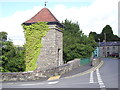
Sewage Pump House, Sennybridge
Located on the A40 at the end of the bridge over the Afon Senni
Image: © Chris Andrews
Taken: 19 Sep 2012
0.05 miles