IMAGES TAKEN NEAR TO
Sennybridge, BRECON, LD3 8PN
Introduction
This page details the photographs taken nearby to LD3 8PN by members of the Geograph project.
The Geograph project started in 2005 with the aim of publishing, organising and preserving representative images for every square kilometre of Great Britain, Ireland and the Isle of Man.

There are currently over 7.5m images from over14,400 individuals and you can help contribute to the project by visiting https://www.geograph.org.uk
Image Map
Images are licensed for reuse under creativecommons.org/licenses/by-sa/2.0
Notes
- Clicking on the map will re-center to the selected point.
- The higher the marker number, the further away the image location is from the centre of the postcode.
Image Listing (24 Images Found)
Images are licensed for reuse under creativecommons.org/licenses/by-sa/2.0
Image
Details
Distance
1
Public conveniences, High Street, Sennybridge
The facility was open (on a Sunday in July) and was well maintained.
Image: © Jaggery
Taken: 24 Jul 2011
0.21 miles
2
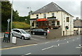
Usk & Railway Inn, Sennybridge
The recently refurbished Usk & Railway Inn is located on the corner of High Street and Defynnog Road. Accommodation is available (6 en-suite rooms).
Image: © Jaggery
Taken: 24 Jul 2011
0.21 miles
3
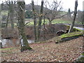
Bridge over the Usk, near Sennybridge
Image: © Roger Cornfoot
Taken: 22 Nov 2008
0.22 miles
4

High Street (A40)
High Street (A40) Sennybridge heading towards Brecon
Image: © Shaun Ferguson
Taken: 16 Aug 2009
0.22 miles
5
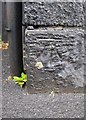
Ordnance Survey Cut Mark
This OS cut mark can be found on an old shop on the NW side of the road. It marks a point 195.288m above mean sea level.
Image: © Adrian Dust
Taken: 21 May 2016
0.23 miles
6

High Street, Sennybridge
Looking down from the village car park which is adjacent to the site once occupied by the station, closed in 1962.
Image: © Stephen McKay
Taken: 26 Aug 2017
0.23 miles
7

Usk and Railway Inn, High Street, Sennybridge
Image: © Colin Pyle
Taken: 19 Sep 2015
0.23 miles
8
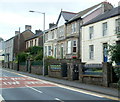
High Street houses, Sennybridge
Houses on the south side of High Street, viewed looking in the direction of the Defynnog Road junction.
Image: © Jaggery
Taken: 24 Jul 2011
0.23 miles
9
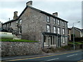
Former High Street shop, Sennybridge
The frontage on the left side of this High Street building suggests that it was formerly a shop.
Ivy Cottage http://www.geograph.org.uk/photo/3061078 is on the right.
Image: © Jaggery
Taken: 24 Jul 2011
0.23 miles
10
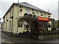
Usk & Railway Inn
Sennybridge - Usk & Railway Inn.
Image: © Alan Hughes
Taken: 28 Jan 2016
0.24 miles