IMAGES TAKEN NEAR TO
Heol Sant Gattwg, BRECON, LD3 8PD
Introduction
This page details the photographs taken nearby to Heol Sant Gattwg, LD3 8PD by members of the Geograph project.
The Geograph project started in 2005 with the aim of publishing, organising and preserving representative images for every square kilometre of Great Britain, Ireland and the Isle of Man.

There are currently over 7.5m images from over14,400 individuals and you can help contribute to the project by visiting https://www.geograph.org.uk
Image Map
Images are licensed for reuse under creativecommons.org/licenses/by-sa/2.0
Notes
- Clicking on the map will re-center to the selected point.
- The higher the marker number, the further away the image location is from the centre of the postcode.
Image Listing (17 Images Found)
Images are licensed for reuse under creativecommons.org/licenses/by-sa/2.0
Image
Details
Distance
1
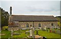
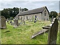
St Cattwg, Llanspyddid
The North side.
Image: © Philip Pankhurst
Taken: 27 Apr 2015
0.05 miles
2
St Cattwg's Church, Llanspyddid
The church is dedicated to St Cattwg, a Welsh saint born in 497AD.
Image: © Maigheach-gheal
Taken: 24 Sep 2010
0.06 miles
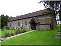
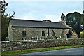
3
St Cattwg, Llanspyddid
A charming 14th century church by the A 40, just West of Brecon.
Image: © Philip Pankhurst
Taken: 27 Apr 2015
0.06 miles
4
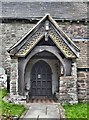
St Cattwg, Llanspyddid
The fine 14th century South porch.
Image: © Philip Pankhurst
Taken: 27 Apr 2015
0.06 miles
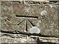
6
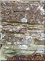
Bench Mark, St Cattwg's Church
The bench mark is to be found on the west face of the church. For a view of the church http://www.geograph.org.uk/photo/2082459 and for further information on the bench mark http://www.bench-marks.org.uk/bm24734
A bench mark is an Ordnance Survey arrowhead sign found on walls, bridges, churches and specially erected triangulation pillars where the altitude above sea-level has been accurately measured by surveyors. The arrowhead points to a horizontal line above it which marks the exact altitude.
With rivets and pivots there is no datum (horizontal line) cut, the pointed-to horizontal surface defining the datum height.
Image: © Maigheach-gheal
Taken: 24 Sep 2010
0.07 miles
7
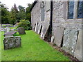
St Cattwg's Church, Llanspyddid
The churchyard contains many old and interesting gravestones many of which have been placed against the church wall.
Image: © Maigheach-gheal
Taken: 24 Sep 2010
0.07 miles
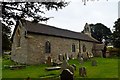
8
St Cattwg, Llanspyddid
Long, low single chamber building by the A40. Of medieval origin, but restored by F.R. Kempson in 1879-80.
Image: © Philip Pankhurst
Taken: 27 Apr 2015
0.07 miles

10
Ordnance Survey 1GL Bolt
This OS Bolt can be found on the SW face of St Cattwg's Church. It marks a point 154.410m above mean sea level.
Image: © Adrian Dust
Taken: 7 Jun 2015
0.07 miles