IMAGES TAKEN NEAR TO
Ffynnon Dewi, BRECON, LD3 8DT
Introduction
This page details the photographs taken nearby to Ffynnon Dewi, LD3 8DT by members of the Geograph project.
The Geograph project started in 2005 with the aim of publishing, organising and preserving representative images for every square kilometre of Great Britain, Ireland and the Isle of Man.

There are currently over 7.5m images from over14,400 individuals and you can help contribute to the project by visiting https://www.geograph.org.uk
Image Map
Images are licensed for reuse under creativecommons.org/licenses/by-sa/2.0
Notes
- Clicking on the map will re-center to the selected point.
- The higher the marker number, the further away the image location is from the centre of the postcode.
Image Listing (167 Images Found)
Images are licensed for reuse under creativecommons.org/licenses/by-sa/2.0
Image
Details
Distance
1
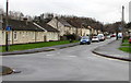
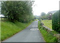
West along Ffynnon Dewi, Llanfaes, Brecon
The sign on the left shows that Ffynnon Dewi is not a through route for motor vehicles.
Image: © Jaggery
Taken: 2 Dec 2018
0.03 miles
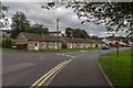
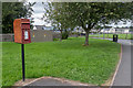
2
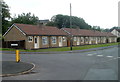
Ffynnon Dewi bungalows, Brecon
Viewed across Bailihelig Road.
Image: © Jaggery
Taken: 29 May 2011
0.04 miles
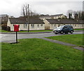
3
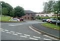
Entrance to Dewi Sant, Llanfaes, Brecon
Viewed from Bailihelig Road. Built in 1985, Dewi Sant is a Powys County Council
property containing 12 flats (housing with support) for people aged at least 55.
Image: © Jaggery
Taken: 29 May 2011
0.04 miles
4
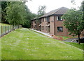
Dewi Sant, Llanfaes, Brecon
Viewed from the entrance from Bailihelig Road. Built in 1985, Dewi Sant is a Powys County Council property containing 12 flats (housing with support) for people aged at least 55.
Image: © Jaggery
Taken: 29 May 2011
0.04 miles
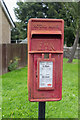
5
Speed limit increases from 20mph to 30mph on Bailihelig Road, Llanfaes, Brecon
The 20mph speed limit applies near the entrance to Llanfaes Primary School. http://www.geograph.org.uk/photo/3005049
Image: © Jaggery
Taken: 29 May 2011
0.04 miles
7
Ffynnon Dewi bungalows, Llanfaes, Brecon
Viewed from the corner of Bailihelig Road. Originally, bungalow was used in English for a lightly-built house, with a veranda and one storey. In current UK usage it is a convenient word for any one-storey dwelling.
Image: © Jaggery
Taken: 2 Dec 2018
0.07 miles
10
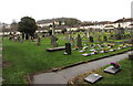
St David's Churchyard, Llanfaes, Brecon
On the southwest side of the Parish Church of St David.
Ffynnon Dewi houses are in the background.
Image: © Jaggery
Taken: 2 Dec 2018
0.08 miles