IMAGES TAKEN NEAR TO
Ger Y Tarrell, BRECON, LD3 8DE
Introduction
This page details the photographs taken nearby to Ger Y Tarrell, LD3 8DE by members of the Geograph project.
The Geograph project started in 2005 with the aim of publishing, organising and preserving representative images for every square kilometre of Great Britain, Ireland and the Isle of Man.

There are currently over 7.5m images from over14,400 individuals and you can help contribute to the project by visiting https://www.geograph.org.uk
Image Map
Images are licensed for reuse under creativecommons.org/licenses/by-sa/2.0
Notes
- Clicking on the map will re-center to the selected point.
- The higher the marker number, the further away the image location is from the centre of the postcode.
Image Listing (161 Images Found)
Images are licensed for reuse under creativecommons.org/licenses/by-sa/2.0
Image
Details
Distance
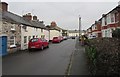
1
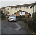
Trenewydd Care Home, Brecon
Viewed from the north side of the B4601 Newgate Street. The Welsh/English
BUPA nameboard shows Gartref Gofal Trenewydd/Trenewydd Care Home.
Image: © Jaggery
Taken: 13 Jan 2019
0.04 miles
2
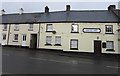
Drovers Arms, Brecon
The Grade II listed pub on the north side of the B4601 Newgate Street was built as an inn c1800.
Image: © Jaggery
Taken: 23 Dec 2018
0.05 miles
3
Drovers Arms, Llanfaes
The pub on Newgate Street bears witness to the agricultural significance of this route down the Usk valley. There are several other present and former inns on the B4601 as it progresses through what is now a western suburb of Brecon. This is opposite the junction with Ffrwydgrech Road, where the Taff Trail joins the B road.
Image: © Derek Harper
Taken: 28 Sep 2011
0.05 miles
4
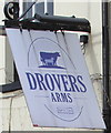
Drovers Arms name sign, Brecon
Gently swaying in the breeze, the sign is just out of shot on the right here. https://www.geograph.org.uk/photo/6006678
Viewed in December 2018. The sign has replaced this one https://www.geograph.org.uk/photo/3005231 on display in May 2011.
Image: © Jaggery
Taken: 23 Dec 2018
0.05 miles
5
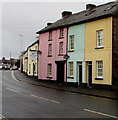
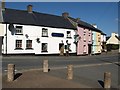
Pastel colours in Llanfaes, Brecon
Three colourful houses on the north side of the B4601 Newgate Street.
The pink house is next door to the Drovers Arms. https://www.geograph.org.uk/photo/6006678
Image: © Jaggery
Taken: 23 Dec 2018
0.05 miles
6
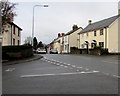
Junction of Ffrwdgrech Road and Newgate Street, Brecon
From the left, Ffrwdgrech Road joins the B4601 Newgate Street.
Image: © Jaggery
Taken: 23 Dec 2018
0.05 miles
7
Telecoms cabinet near Old Castle Farm, Brecon
The dark green cabinet on the north side of the B4601 is a few metres from
the red wheelie bin at the edge of Old Castle Farm guesthouse. https://www.geograph.org.uk/photo/6006671
Image: © Jaggery
Taken: 23 Dec 2018
0.06 miles
8
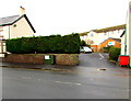
Bench and litter bin on a Llanfaes corner, Brecon
On the Ffrwdgrech Road side of the corner of the B4601 Newgate Street in the Llanfaes area of Brecon.
Image: © Jaggery
Taken: 23 Dec 2018
0.06 miles
9
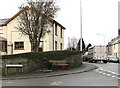
Contrasting sides of Ffrwdgrech Road, Brecon
Different styles of houses on the west and east side of the road viewed looking NNE towards Newgate Street.
Image: © Jaggery
Taken: 23 Dec 2018
0.06 miles
10
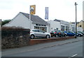
Brecon Car Sales, Llanfaes, Brecon
Renault specialist car dealers located alongside the B4601, the main road through Llanfaes, Brecon.
Image: © Jaggery
Taken: 29 May 2011
0.06 miles