1
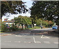
Silver Street houses and cars, Brecon
Viewed from near the B4601 junction.
Image: © Jaggery
Taken: 7 Oct 2018
0.01 miles
2
Access road from Silver Street to Tŷ Henry Vaughan, Brecon
The road leads to Tŷ Henry Vaughan https://www.geograph.org.uk/photo/5933747 the main surgery of Brecon Medical Group Practice.
Image: © Jaggery
Taken: 7 Oct 2018
0.01 miles
3
North along Silver Street, Brecon
Viewed across the B4601. The sign on the lamppost shows that Silver Street is not a through route for vehicles.
Image: © Jaggery
Taken: 7 Oct 2018
0.01 miles
4
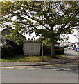
Silver Street electricity substation, Brecon
The Western Power Distribution electricity substation identifier is S/S 614721.
Image: © Jaggery
Taken: 7 Oct 2018
0.01 miles
5
Rear of the Beacons Guesthouse, Brecon
The front of the Beacons Guesthouse is at 16 Bridge Street alongside the B4601.
Image: © Jaggery
Taken: 7 Oct 2018
0.02 miles
6
St. Joseph's Catholic Primary School, Brecon
The Roman Catholic school is located between Silver Street and the south bank of the River Usk. Established in 1950, the school opened on this site, formerly known as Kelly's Field, in 1976.
Image: © Jaggery
Taken: 29 May 2011
0.02 miles
7
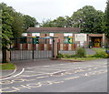
Entrance gates to Brecon Pupil Referral Unit, Brecon
Viewed in October 2018. The site was formerly occupied by St Joseph's Roman Catholic School which closed down in 2013.
Image: © Jaggery
Taken: 7 Oct 2018
0.02 miles
8
Bilingual Powys County Council site name sign, Brecon
On the right here. https://www.geograph.org.uk/photo/5933766 Brecon Pupil Referral Unit is Uned Atgyfeirio Disgyblion Aberhonddu in Welsh.
Image: © Jaggery
Taken: 7 Oct 2018
0.02 miles
9
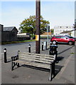
Bench and litter bin on a Brecon corner
On the corner of Bridge Street and Silver Street.
Image: © Jaggery
Taken: 7 Oct 2018
0.03 miles
10
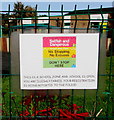
Selfish and dangerous in Brecon
The notice is on the perimeter fence of Brecon Pupil Referral Unit near the entrance gates. https://www.geograph.org.uk/photo/5933766 The notice states that stopping (your vehicle) on the zigzags is selfish and dangerous. No stopping - no excuses. Don't stop here. This is a School Zone and school is open. You are illegally parked. Your registration is being reported to the police!
Image: © Jaggery
Taken: 7 Oct 2018
0.04 miles


