IMAGES TAKEN NEAR TO
Newmarch Street, BRECON, LD3 8AU
Introduction
This page details the photographs taken nearby to Newmarch Street, LD3 8AU by members of the Geograph project.
The Geograph project started in 2005 with the aim of publishing, organising and preserving representative images for every square kilometre of Great Britain, Ireland and the Isle of Man.

There are currently over 7.5m images from over14,400 individuals and you can help contribute to the project by visiting https://www.geograph.org.uk
Image Map
Images are licensed for reuse under creativecommons.org/licenses/by-sa/2.0
Notes
- Clicking on the map will re-center to the selected point.
- The higher the marker number, the further away the image location is from the centre of the postcode.
Image Listing (332 Images Found)
Images are licensed for reuse under creativecommons.org/licenses/by-sa/2.0
Image
Details
Distance
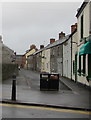
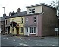
1
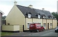
Newmarch Street houses, Brecon
Houses at the northern end of Newmarch Street, near the corner of Silver Street
in the Llanfaes district of Brecon.
Image: © Jaggery
Taken: 29 May 2011
0.02 miles
2
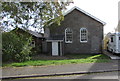
Former Tabernacle chapel, Newmarch Street, Brecon
Viewed in October 2018. The former chapel was converted to residential use many years ago. The faded and decaying tablet https://www.geograph.org.uk/photo/6200910 on the wall shows TABERNACLE WELSH WESLEYAN CHAPEL ERECTED A.D. 1871
Image: © Jaggery
Taken: 7 Oct 2018
0.04 miles
3
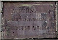
Faded tablet on the former Tabernacle chapel, Newmarch Street, Brecon
The tablet on the wall here https://www.geograph.org.uk/photo/6200904 shows
TABERNACLE WELSH WESLEYAN CHAPEL ERECTED A.D. 1871
Image: © Jaggery
Taken: 7 Oct 2018
0.04 miles
4
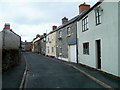
St David Street, Brecon
Looking NW from near the Orchard Street end.
Image: © Jaggery
Taken: 29 May 2011
0.04 miles
5
NW along St David Street, Brecon
Looking to the northwest along St David Street from the B4061 Orchard Street.
West End Fish Bar https://www.geograph.org.uk/photo/5991303 is on the right.
Image: © Jaggery
Taken: 2 Dec 2018
0.04 miles
6
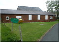
Westenders Hall, Brecon
Westenders Hall is a community centre in Silver Street in the Llanfaes district of Brecon.
Image: © Jaggery
Taken: 29 May 2011
0.04 miles
7
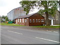
Corner of Silver Street and Newmarch Street Brecon
The large corrugated building on the left is The Warehouse. http://www.geograph.org.uk/photo/3020697
The wooden building is Westenders Hall. http://www.geograph.org.uk/photo/3122931
The building on the right of the hall looks as though it may once have been a church or chapel.
Image: © Jaggery
Taken: 29 May 2011
0.04 miles
8
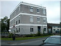
Brecon Telephone Exchange
British Telecom premises on the corner of Silver Street and Walnut Square.
Image: © Jaggery
Taken: 29 May 2011
0.05 miles
9
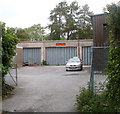
BT motor transport workshop, Brecon
Located near British Telecom's Brecon Telephone Exchange, http://www.geograph.org.uk/photo/3020625 the workshop retains its Post Office name board. British Telecom (BT) was formed in 1980. It became independent of the Post Office in 1981, and was privatised in 1984.
Image: © Jaggery
Taken: 29 May 2011
0.05 miles
10
Eastern end of Orchard Street, Brecon
Bridge Street behind the camera becomes Orchard Street ahead on passing the Silver Street junction. The large Silver Street name sign on the right shows the names of five other streets accessible via Silver Street.
Image: © Jaggery
Taken: 29 May 2011
0.05 miles