IMAGES TAKEN NEAR TO
Llansantffraed, BRECON, LD3 7YF
Introduction
This page details the photographs taken nearby to LD3 7YF by members of the Geograph project.
The Geograph project started in 2005 with the aim of publishing, organising and preserving representative images for every square kilometre of Great Britain, Ireland and the Isle of Man.

There are currently over 7.5m images from over14,400 individuals and you can help contribute to the project by visiting https://www.geograph.org.uk
Image Map
Images are licensed for reuse under creativecommons.org/licenses/by-sa/2.0
Notes
- Clicking on the map will re-center to the selected point.
- The higher the marker number, the further away the image location is from the centre of the postcode.
Image Listing (64 Images Found)
Images are licensed for reuse under creativecommons.org/licenses/by-sa/2.0
Image
Details
Distance
2
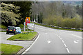
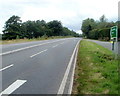
A40 from Llansantffraed towards Brecon
The sign on the right shows Aberhonddu/Brecon 6 (miles).
Image: © Jaggery
Taken: 7 Jul 2019
0.04 miles
3
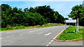
A40 road junction, Llansantffraed
Viewed from the hairpin bend http://www.geograph.org.uk/photo/2590786 on the road from Talybont-on-Usk. Turn left for Brecon (6 miles) or right for Crickhowell (8 miles) or Abergavenny (14 miles).
Image: © Jaggery
Taken: 10 Jul 2011
0.04 miles
4
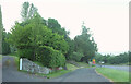
Lay-by, Llansantffraed
Providing parking for the church and visitors to Henry Vaughan's grave. On the left is the driveway to Llansantffraed House.
Image: © Derek Harper
Taken: 23 Jun 2021
0.04 miles
5
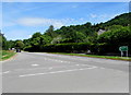
Six miles to Brecon from Llansantffraed
Viewed from near a hairpin bend. http://www.geograph.org.uk/photo/3112074
The A40 heads away from Llansantffraed towards Brecon, 6 miles away.
Image: © Jaggery
Taken: 10 Jul 2011
0.04 miles
6
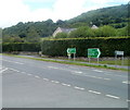
Talybont-on-Usk direction sign, Llansantffraed, Powys
The sign alongside the A40 points towards a minor road. https://www.geograph.org.uk/photo/6205850
The sign shows that Talybont-on-Usk is Tal-y-bont-ar-Wysg in Welsh.
Image: © Jaggery
Taken: 7 Jul 2019
0.05 miles
7
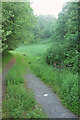
Track, Llansantffraed
Leading down from the A40 to the dismantled railway line.
Image: © Derek Harper
Taken: 23 Jun 2021
0.06 miles
8
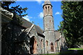
Spire of St Ffraed's Church, Llansantffraed
Unusual octagonal stone spire on south side of church rebuilt in the Gothic style in the late nineteenth century. The main door, left, to the church is shown in Image
Image: © M J Roscoe
Taken: 15 Apr 2021
0.06 miles
9
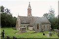
Church of St Ffraed, Llansantffraed
"A medieval church rebuilt in 1690 preceded the current building, constructed 1884-5 by Stephen Williams of Rhayader ... Gothic Revival church built of snecked rockfaced stone with red sandstone dressings and tiled roof with bracketed eaves ... The spire is the most unusual feature: octagonal, 3 tapered storeys, and of contrasting stone, the top storey of red sandstone ashlar and the lower storeys separated by red ashlar offsets ..." https://cadwpublic-api.azurewebsites.net/reports/listedbuilding/FullReport?lang=&id=21144 .
Image: © Derek Harper
Taken: 23 Jun 2021
0.06 miles
10
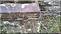
Ordnance Survey Cut Mark
This OS cut mark can be found on the west face of St Freda's Church. It marks a point 122.574m above mean sea level.
Image: © Adrian Dust
Taken: 19 Jan 2019
0.06 miles