IMAGES TAKEN NEAR TO
Meadow View, BRECON, LD3 7TX
Introduction
This page details the photographs taken nearby to Meadow View, LD3 7TX by members of the Geograph project.
The Geograph project started in 2005 with the aim of publishing, organising and preserving representative images for every square kilometre of Great Britain, Ireland and the Isle of Man.

There are currently over 7.5m images from over14,400 individuals and you can help contribute to the project by visiting https://www.geograph.org.uk
Image Map
Images are licensed for reuse under creativecommons.org/licenses/by-sa/2.0
Notes
- Clicking on the map will re-center to the selected point.
- The higher the marker number, the further away the image location is from the centre of the postcode.
Image Listing (31 Images Found)
Images are licensed for reuse under creativecommons.org/licenses/by-sa/2.0
Image
Details
Distance
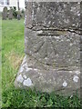
1
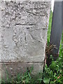
Ordnance Survey Cut Mark
This OS cut mark can be found on the NW face of a roadside outbuilding at Pen Y Pentre Farm. It marks a point 181.825m above mean sea level.
Image: © Adrian Dust
Taken: 21 Apr 2016
0.09 miles
2
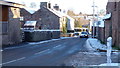
Llanfihangel Tal-y-llyn
Compact village to the north-west of Llangorse Lake.
Image: © Jonathan Billinger
Taken: 14 Jan 2015
0.10 miles
4

Community Hall in Llanfihangel Talyllyn, Powys
In September 2023 the nameboard shows
Llanfihangel Talyllyn • Talyllyn & Llanwern
Image: © Jaggery
Taken: 3 Sep 2023
0.12 miles
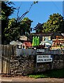
5

Children's playground in Llanfihangel Talyllyn, Powys
Set back from the south side of the main road
through the village, near the Spring Meadow junction.
Image: © Jaggery
Taken: 3 Sep 2023
0.15 miles
6
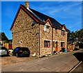
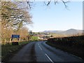
Trefechan Pistyll, Llanfihangel Talyllyn, Powys
Trefechan Pistyll is a detached house located
opposite the western edge of St Michael's churchyard.
The main road through the village is behind the camera.
Image: © Jaggery
Taken: 3 Sep 2023
0.15 miles
7
Bilingual street name sign, Llanfihangel Talyllyn, Powys
The sign facing the main road through the village shows that this https://www.geograph.org.uk/photo/7585791
cul-de-sac is Spring Meadow in English, Dôl Pistyll in Welsh.
Image: © Jaggery
Taken: 3 Sep 2023
0.15 miles
8
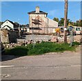
Fenced-off demolition site, Llanfihangel Talyllyn, Powys
Viewed in September 2023. The farm building seen in
a March 2021 Google Street View has been demolished.
Image: © Jaggery
Taken: 3 Sep 2023
0.16 miles
9

Queen Elizabeth II postbox, Llanfihangel Talyllyn, Powys
Alongside the main road through the village, near the corner of Spring Meadow.
Image: © Jaggery
Taken: 3 Sep 2023
0.16 miles
10
Ordnance Survey Cut Mark
This OS cut mark can be found on the south east face of St Michael and All Angels Church. It marks a point 178.736m above mean sea level.
Image: © Adrian Dust
Taken: 21 Apr 2016
0.17 miles