IMAGES TAKEN NEAR TO
Free Street, BRECON, LD3 7SE
Introduction
This page details the photographs taken nearby to Free Street, LD3 7SE by members of the Geograph project.
The Geograph project started in 2005 with the aim of publishing, organising and preserving representative images for every square kilometre of Great Britain, Ireland and the Isle of Man.

There are currently over 7.5m images from over14,400 individuals and you can help contribute to the project by visiting https://www.geograph.org.uk
Image Map
Images are licensed for reuse under creativecommons.org/licenses/by-sa/2.0
Notes
- Clicking on the map will re-center to the selected point.
- The higher the marker number, the further away the image location is from the centre of the postcode.
Image Listing (1024 Images Found)
Images are licensed for reuse under creativecommons.org/licenses/by-sa/2.0
Image
Details
Distance
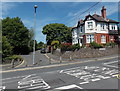
2
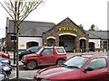
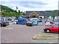
Morrisons Supermarket, Brecon
Viewed in November 2018. The supermarket is on part of the site formerly
occupied by Brecon railway station where passenger services ended in December 1962.
Image: © Jaggery
Taken: 4 Nov 2018
0.01 miles
3
Morrisons Brecon
Town centre supermarket viewed across Heol Gouesnou from the corner of Camden Road.
Image: © Jaggery
Taken: 7 Jul 2013
0.02 miles
4
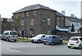
Markets Tavern Hotel, Brecon
The Markets Tavern Hotel, dating from the mid 19th century, was Grade II listed in 1976. It is a pub with B&B (Bed and Breakfast) accommodation available, located at the northern end of Free Street in central Brecon. Formerly nearby was an entrance to Brecon cattle market (now Cattle Market car park).
Some sources refer to "Market Tavern" but all the signs on the building show "Markets Tavern".
Image: © Jaggery
Taken: 29 May 2011
0.03 miles
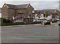
5
Plough Court, Brecon
Officially opened on May 31st 2012, Plough Court is a Wales & West Housing Association development of 21 flats and 5 houses on a site previously occupied by a derelict police station.
Image: © Jaggery
Taken: 27 May 2013
0.04 miles
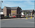
6
Morrison's, Brecon
Yes it is Morrison's now! Image Back in the 1960s when I was living in the area, this was the railway station and trains came into Brecon from four different directions (Newtown, Hereford, Merthyr Tydfil and Neath). Now, as in so many towns, the closure of the station and railway has created a large town centre site for the inevitable carpark and supermarket.
Image: © Oliver Dixon
Taken: 20 Jun 2006
0.04 miles
7
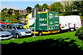
Morrisons home delivery van, Brecon
In a car park near Morrisons supermarket https://www.geograph.org.uk/photo/5965013 in September 2020.
Image: © Jaggery
Taken: 13 Sep 2020
0.04 miles
8
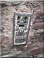
Ordnance Survey Flush Bracket (1100)
This OS Flush Bracket can be found on the NW face of Markets Tavern. It marks a point 136.076m above mean sea level.
Image: © Adrian Dust
Taken: 31 May 2014
0.05 miles
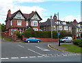
9
Corner of Cerrigcochion Road and Alexandra Road, Brecon
Looking across the B4602 Cerrigcochion Road towards Alexandra Road.
Image: © Jaggery
Taken: 7 Jul 2013
0.05 miles
10
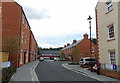
Alexandra Road houses, Brecon
Viewed from Heol Gouesnou.
Image: © Jaggery
Taken: 24 Jun 2012
0.05 miles