IMAGES TAKEN NEAR TO
Bwlch, BRECON, LD3 7NX
Introduction
This page details the photographs taken nearby to LD3 7NX by members of the Geograph project.
The Geograph project started in 2005 with the aim of publishing, organising and preserving representative images for every square kilometre of Great Britain, Ireland and the Isle of Man.

There are currently over 7.5m images from over14,400 individuals and you can help contribute to the project by visiting https://www.geograph.org.uk
Image Map
Images are licensed for reuse under creativecommons.org/licenses/by-sa/2.0
Notes
- Clicking on the map will re-center to the selected point.
- The higher the marker number, the further away the image location is from the centre of the postcode.
Image Listing (21 Images Found)
Images are licensed for reuse under creativecommons.org/licenses/by-sa/2.0
Image
Details
Distance
1
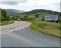
Bend in the A40 at the junction for Llangynidr
Viewed from the edge of the B4560, the Llangynidr road. The course of the A40 heading away from Bwlch changes from southward to eastward here.
Image: © Jaggery
Taken: 17 Jun 2012
0.02 miles
2
Road from Llangynidr reaches the A40
This is the northern end of the B4560, at the A40 junction. Ahead is a long climb into the centre of Bwlch, a small village in Powys.
Image: © Jaggery
Taken: 17 Jun 2012
0.02 miles
3
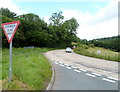
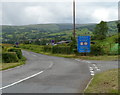
A40 approaches the Llangynidr junction south of Bwlch
The sign shows a 90-degree bend in the A40 ahead, at the junction with the B4560.
There are weight (maximum 7.5 tonnes) and width (maximum 7" or just over 2 metres)
restrictions three-quarters of a mile away along the B4560, at Llangynidr Bridge across the River Usk.
This section of the A40 is not a pleasant one for walkers. There are no pavements, and only a narrow walking space between the roadway and hedges.
Image: © Jaggery
Taken: 17 Jun 2012
0.05 miles
4
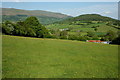
View to the east from the lower slopes of Buckland Hill
View to the east from near Bwlch on the lower slopes of Buckland Hill, the wooded hill on the right is Myarth and Pen Cerrig-calch is on the horizon.
Image: © Philip Halling
Taken: 23 May 2009
0.06 miles
5
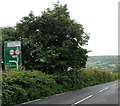
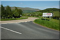
Road south to Llangynidr
The B4560 heads away from the A40 towards the Powys village of Llangynidr.
The large blue sign warns of vehicle weight and width restrictions ahead (on Llangynidr Bridge across the River Usk). The side road on the right leads to farms.
Image: © Jaggery
Taken: 17 Jun 2012
0.07 miles
6
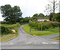
Access road to Cornerways south of Bwlch
The access road connects with the B4560 (the Llangynidr road) near the A40 junction.
Image: © Jaggery
Taken: 17 Jun 2012
0.07 miles
7
Road junction on the A40
Junction of the road to Llangynidr with the A40 to the south of Bwlch. The wooded hill on the right is Myarth and Pen Cerrig-calch is in the distance.
Image: © Philip Halling
Taken: 23 May 2009
0.08 miles
8
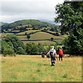
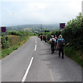
Tuag at Corner Ways / Towards Corner Ways
Cerddwyr yn dilyn Ffordd y Bannau i gyfeiriad anhedd-dy o'r enw Corner Ways. Enw'r tyle yn y pellter yw Myarth.
Walkers following the Beacons Way in the direction of a property known as Corner Ways. The hill in the distance is called Myarth.
Image: © Alan Richards
Taken: 24 Jul 2016
0.09 miles
9
Ger Pant y beili / Near Pant y Beili
Cerddwyr yn dilyn y B4560 i gyfeiriad Llangynidr.
Walkers following the B4560 in the direction of Llangyndir (trans. church of Cynidr).
Image: © Alan Richards
Taken: 24 Jul 2016
0.09 miles
10
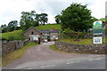
Pant-y-beili Farm south of Bwlch
Viewed across the B4560, the road to Llangynidr. The sign on the right shows that free-range pork, beef and eggs are available. A sign on the left shows that the farm is open for the sale of the free-range produce on Mondays, Wednesdays, Fridays and Saturdays. Closed on Sundays, Tuesdays and Thursdays. The farm is closed today, a Sunday.
Image: © Jaggery
Taken: 17 Jun 2012
0.13 miles