1
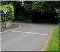
Junction at the northern end of Captain's Field, Llanfrynach
The cul-de-sac Captain's Field is on the right. The road ahead leads to the B4558.
Image: © Jaggery
Taken: 14 Jul 2019
0.05 miles
2
Old barn,Ty Mawr Farm, Llanfrynach
Some of the brick columns supporting the roof are no longer exactly vertical. The barn is to be redeveloped for residential use. http://www.geograph.org.uk/photo/2737208
Image: © Jaggery
Taken: 2 Oct 2011
0.05 miles
3
Ty Mawr farmhouse, Llanfrynach
A sign on the gate shows "Construction site keep out".
A Brecon Beacons National Park Notice of Proposed Development on display nearby states that there is a proposal to convert the existing barn to provide extended residential accommodation to the existing dwelling.
Image: © Jaggery
Taken: 2 Oct 2011
0.05 miles
4
Entrance to Ty Mawr, Llanfrynach
The entrance drive is at the SE edge of Ty Mawr, an early nineteenth century mansion adjacent to Ty Mawr Farm.
Image: © Jaggery
Taken: 2 Oct 2011
0.05 miles
5
NE boundary of Llanfrynach
Llanfrynach is a small village in the Brecon Beacons National Park, Powys, located SE of the town of Brecon. The B4558 junction is about 250 metres behind the camera.
Image: © Jaggery
Taken: 2 Oct 2011
0.05 miles
6
Ildiwch/Give Way, Captain's Field, Llanfrynach
The Welsh/English sign faces the cul-de-sac Captain's Field at the junction with the road leading to the B4558.
Image: © Jaggery
Taken: 14 Jul 2019
0.05 miles
7
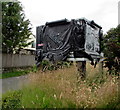
Closed, Llanfrynach
In July 2019 partly-torn black plastic sheeting showing CLOSED covers the sign at the entrance to the car park of the former White Swan. The White Swan is abandoned and boarded-up. https://www.geograph.org.uk/photo/6211049
Image: © Jaggery
Taken: 14 Jul 2019
0.05 miles
8
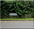
Bilingual name sign, Captain's Field, Llanfrynach
The sign on the right here https://www.geograph.org.uk/photo/6211091 shows that Captain's Field is Maes y Capten in Welsh.
Image: © Jaggery
Taken: 14 Jul 2019
0.05 miles
9
Llanfrynach church
Image: © Gareth James
Taken: 2 Aug 2010
0.06 miles
10
The White Swan public house at Llanfrynach
Image: © David Martin
Taken: 21 Jul 2017
0.06 miles


