IMAGES TAKEN NEAR TO
Free Street, BRECON, LD3 7BL
Introduction
This page details the photographs taken nearby to Free Street, LD3 7BL by members of the Geograph project.
The Geograph project started in 2005 with the aim of publishing, organising and preserving representative images for every square kilometre of Great Britain, Ireland and the Isle of Man.

There are currently over 7.5m images from over14,400 individuals and you can help contribute to the project by visiting https://www.geograph.org.uk
Image Map
Images are licensed for reuse under creativecommons.org/licenses/by-sa/2.0
Notes
- Clicking on the map will re-center to the selected point.
- The higher the marker number, the further away the image location is from the centre of the postcode.
Image Listing (907 Images Found)
Images are licensed for reuse under creativecommons.org/licenses/by-sa/2.0
Image
Details
Distance
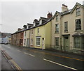
1
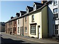
Free Street, Brecon
This terrace can be seen on the left of Image
Image: © Derek Harper
Taken: 28 Sep 2011
0.01 miles
2
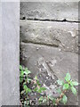
Ordnance Survey Cut Mark
This OS cut mark can be found on No23 Free Street. It marks a point 134.588m above mean sea level.
Image: © Adrian Dust
Taken: 31 May 2014
0.01 miles
3
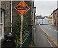
Liberal Democrats orange lozenge placard, Free Street, Brecon
On display on November 24th 2019. The 2019 UK General Election will be held on Thursday December 12th 2019 - the first UK General Election to be held in December since 1923. Brecon is part of the Brecon and Radnorshire Parliamentary Constituency of the House of Commons. Until 1997 its name was Brecon and Radnor.
Image: © Jaggery
Taken: 24 Nov 2019
0.01 miles
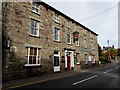
5
Grade II listed Arfon House, Free Street, Brecon
The later 19th century house on the right was Grade II listed in 1976.
Image: © Jaggery
Taken: 2 Dec 2018
0.01 miles
6
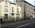
Arfon House, Free Street, Brecon
The Grade II listed later 19th century house is next door to the Markets Tavern Hotel which is also Grade II listed.
Image: © Jaggery
Taken: 7 Oct 2018
0.01 miles
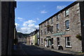
7
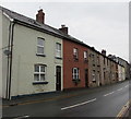
Free Street houses, Brecon
Looking to the NNE along Free Street. The Markets Tavern Hotel https://www.geograph.org.uk/photo/6197727 is on the far right.
Image: © Jaggery
Taken: 24 Nov 2019
0.02 miles
8
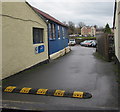
Entrance to Roy Hatton Car Sales premises, Brecon
From Free Street.
Image: © Jaggery
Taken: 24 Nov 2019
0.02 miles
9
Markets Tavern Hotel, Brecon
Looking down Free Street along the southeast facade; Image shows the front on the right, facing northeast.
Image: © Derek Harper
Taken: 28 Sep 2011
0.02 miles
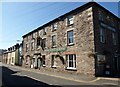
10
Grade II Listed Markets Tavern Hotel, Free Street, Brecon
The large town centre hotel dating from the 19th century used to be at an entrance to Brecon cattle market.
The present-day livestock market is alongside the A40 at the edge of Brecon.
Image: © Jaggery
Taken: 7 Oct 2018
0.02 miles