IMAGES TAKEN NEAR TO
Llanfrynach, BRECON, LD3 7AJ
Introduction
This page details the photographs taken nearby to LD3 7AJ by members of the Geograph project.
The Geograph project started in 2005 with the aim of publishing, organising and preserving representative images for every square kilometre of Great Britain, Ireland and the Isle of Man.

There are currently over 7.5m images from over14,400 individuals and you can help contribute to the project by visiting https://www.geograph.org.uk
Image Map
Images are licensed for reuse under creativecommons.org/licenses/by-sa/2.0
Notes
- Clicking on the map will re-center to the selected point.
- The higher the marker number, the further away the image location is from the centre of the postcode.
Image Listing (97 Images Found)
Images are licensed for reuse under creativecommons.org/licenses/by-sa/2.0
Image
Details
Distance
1
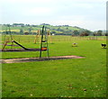
Children's play area, Llanfrynach
Located in the northern side of the village.
Image: © Jaggery
Taken: 2 Oct 2011
0.02 miles
2
North along a minor road through Llanfrynach, Powys
Ahead for the B4558 which leads to the A40.
Image: © Jaggery
Taken: 14 Jul 2019
0.02 miles
3
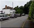
Llanfrynach semis, Powys
Semi-detached houses in Llanfrynach, a village about 3 miles (5km) southeast of Brecon.
The village's population on the day of the 2011 UK Census was 571.
Image: © Jaggery
Taken: 14 Jul 2019
0.03 miles
4
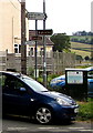
Direction and distance signs, Llanfrynach, Powys
Located here https://www.geograph.org.uk/photo/6496796 3 miles from Brecon (Aberhonddu in Welsh) and 1¼ miles from Cantref. Also in view are brown Taff Trail direction signs.
Image: © Jaggery
Taken: 14 Jul 2019
0.03 miles
5
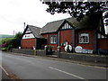
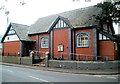
Llanfrynach and Cantref Community Hall, Powys
Located in Llanfrynach. The village website records that the hall which serves the communities of Llanfrynach and Cantref is an attractive traditional red brick slate-roofed building with a touch of Arts and Crafts style. It was built in 1912 under a large oak tree on what was at the time the edge of Llanfrynach village. It was paid for by the Brecon Beacons commoners with money given to them by Merthyr Tydfil District Council in payment for the loss of grazing land when the Upper Neuadd Reservoir was built.
Image: © Jaggery
Taken: 14 Jul 2019
0.04 miles
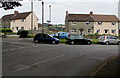
6
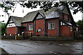
Llanfrynach and Cantref Community Hall
Image: © David Martin
Taken: 21 Jul 2017
0.04 miles
7
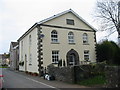
Mizpah Baptist Chapel
The plaque near the roof reads "Mizpah Baptist Chapel Built 1862". It ghas been converted into two private homes.
Image: © Simon Atkin
Taken: 4 Apr 2007
0.05 miles
8
Yellow hydrant marker outside the village hall, Llanfrynach, Powys
Near a notice showing NO PARKING PLEASE - ACCESS NEEDED OPPOSITE.
Image: © Jaggery
Taken: 14 Jul 2019
0.05 miles
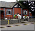
9
Llanfrynach Parish Hall
Llanfrynach is a small village in the Brecon Beacons National Park, Powys, located SE of the town of Brecon.
Image: © Jaggery
Taken: 2 Oct 2011
0.05 miles
10
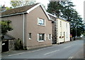
Bec Cottage and The Old Chapel, Llanfrynach
The pebbledashed house is Bec Cottage. Its neighbour, now two dwellings (The Old Chapel, in view, and Mizpah out of view around the corner), was formerly Mizpah Chapel. http://www.geograph.org.uk/photo/407604
Image: © Jaggery
Taken: 2 Oct 2011
0.05 miles