IMAGES TAKEN NEAR TO
Three Cocks, BRECON, LD3 0SH
Introduction
This page details the photographs taken nearby to LD3 0SH by members of the Geograph project.
The Geograph project started in 2005 with the aim of publishing, organising and preserving representative images for every square kilometre of Great Britain, Ireland and the Isle of Man.

There are currently over 7.5m images from over14,400 individuals and you can help contribute to the project by visiting https://www.geograph.org.uk
Image Map
Images are licensed for reuse under creativecommons.org/licenses/by-sa/2.0
Notes
- Clicking on the map will re-center to the selected point.
- The higher the marker number, the further away the image location is from the centre of the postcode.
Image Listing (8 Images Found)
Images are licensed for reuse under creativecommons.org/licenses/by-sa/2.0
Image
Details
Distance
4
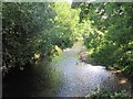
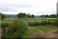
Wye Valley floor near Three Cocks
The valley is wide here at the point where the Dulas flows east into the main stream.
The land use is arable. The hills on the north side of the river are those above Boughrood.
Image: © Jonathan Billinger
Taken: 30 Nov 2014
0.21 miles
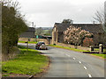
5
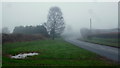
A4079 at Pipton
The sweeping bend as the road approaches the A438.
Shrouded in temperature-inversion fog.
Image: © Jonathan Billinger
Taken: 19 Jan 2016
0.21 miles
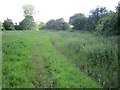
7
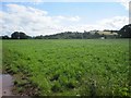
Fields by Pipton
Fields up to the River Wye by Pipton
Image: © Shaun Ferguson
Taken: 26 Aug 2007
0.23 miles
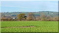
8
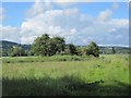
The Mound at Pipton (as per OS marking!)
Image: © Keith Salvesen
Taken: 22 Jun 2011
0.24 miles