IMAGES TAKEN NEAR TO
Llanfilo, BRECON, LD3 0RH
Introduction
This page details the photographs taken nearby to LD3 0RH by members of the Geograph project.
The Geograph project started in 2005 with the aim of publishing, organising and preserving representative images for every square kilometre of Great Britain, Ireland and the Isle of Man.

There are currently over 7.5m images from over14,400 individuals and you can help contribute to the project by visiting https://www.geograph.org.uk
Image Map
Images are licensed for reuse under creativecommons.org/licenses/by-sa/2.0
Notes
- Clicking on the map will re-center to the selected point.
- The higher the marker number, the further away the image location is from the centre of the postcode.
Image Listing (5 Images Found)
Images are licensed for reuse under creativecommons.org/licenses/by-sa/2.0
Image
Details
Distance
1
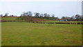
Hillis farm
Hillis farm the gated road offered no indication on the OS marked footpath
Image: © Shaun Ferguson
Taken: 25 Aug 2007
0.04 miles
2
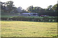
View to The Hillis Farm
Looking towards the farm nestled in the wooded east flank of Allt Filo.
Image: © Jonathan Billinger
Taken: 29 Jan 2015
0.18 miles
3
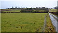
Pasture land
The footpath starting at Image crosses the fields, uphill, here.
Image: © Jonathan Billinger
Taken: 29 Jan 2015
0.19 miles
4
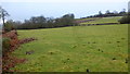
Allt Filo and Hillis Farm
Pictured from opposite the Old School House, also the same position as the first Geograph for this square, Image
Image: © Jonathan Billinger
Taken: 29 Jan 2015
0.19 miles
5
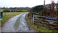
Track to The Hillis farm
Private track to the farm, nestled in woods on the sheltered east side of Allt Filo, with a public path branching diagonally off to the left.
Image: © Jonathan Billinger
Taken: 29 Jan 2015
0.20 miles