IMAGES TAKEN NEAR TO
Llandefalle, BRECON, LD3 0NB
Introduction
This page details the photographs taken nearby to LD3 0NB by members of the Geograph project.
The Geograph project started in 2005 with the aim of publishing, organising and preserving representative images for every square kilometre of Great Britain, Ireland and the Isle of Man.

There are currently over 7.5m images from over14,400 individuals and you can help contribute to the project by visiting https://www.geograph.org.uk
Image Map
Images are licensed for reuse under creativecommons.org/licenses/by-sa/2.0
Notes
- Clicking on the map will re-center to the selected point.
- The higher the marker number, the further away the image location is from the centre of the postcode.
Image Listing (7 Images Found)
Images are licensed for reuse under creativecommons.org/licenses/by-sa/2.0
Image
Details
Distance
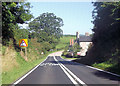
2
The A470 at Brynhaul
Minor road from Bronllys joins the A470 at Brynhaul
Image: © Shaun Ferguson
Taken: 26 Aug 2007
0.19 miles
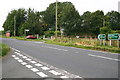
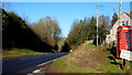
4
Junction with the A470 at Brynhaul, 1
The end of Pont-y-wal Lane from Bronllys.
Image: © Jonathan Billinger
Taken: 19 Jan 2016
0.22 miles
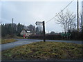
6
Junction with the A470 at Brynhaul, 2
Looking north along the Trunk Road.
Image: © Jonathan Billinger
Taken: 19 Jan 2016
0.24 miles
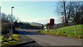
7
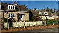
Cottages at Brynhaul
Mid-20th century housing at the end of Pont-y-wal Lane.
Image: © Jonathan Billinger
Taken: 19 Jan 2016
0.25 miles