IMAGES TAKEN NEAR TO
Bronllys Road, BRECON, LD3 0HH
Introduction
This page details the photographs taken nearby to Bronllys Road, LD3 0HH by members of the Geograph project.
The Geograph project started in 2005 with the aim of publishing, organising and preserving representative images for every square kilometre of Great Britain, Ireland and the Isle of Man.

There are currently over 7.5m images from over14,400 individuals and you can help contribute to the project by visiting https://www.geograph.org.uk
Image Map
Images are licensed for reuse under creativecommons.org/licenses/by-sa/2.0
Notes
- Clicking on the map will re-center to the selected point.
- The higher the marker number, the further away the image location is from the centre of the postcode.
Image Listing (58 Images Found)
Images are licensed for reuse under creativecommons.org/licenses/by-sa/2.0
Image
Details
Distance
1
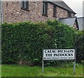
Welsh / English name sign, The Paddocks, Talgarth, Powys
The sign facing Bronllys Road shows that in Welsh, The Paddocks
is Caeau Bychain and Private Road is Ffordd Breifat.
Image: © Jaggery
Taken: 10 Sep 2023
0.03 miles
2
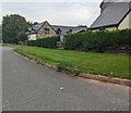
Houses in The Paddocks, Talgarth, Powys
Set back from Bronllys Road. A nearby name sign https://www.geograph.org.uk/photo/7597014
shows that The Paddocks is Caeau Bychain in Welsh.
Image: © Jaggery
Taken: 10 Sep 2023
0.04 miles
3
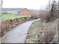
River Ennig
Flowing from Talgarth toward the camera, just by the A479, to enter the Llynfi at Bronllys Castle Bridge.
Image: © Jonathan Billinger
Taken: 19 Jan 2007
0.07 miles
4
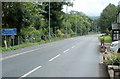
NW boundary of Talgarth
The A479 from Bronllys reaches the Powys market town of Talgarth, population 1,645 (2001 Census)
Image: © Jaggery
Taken: 14 Aug 2011
0.07 miles
5
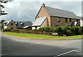
The Paddocks, Talgarth
The Paddocks is a small group of modern houses on the west side of Bronllys Road.
Image: © Jaggery
Taken: 14 Aug 2011
0.07 miles
6
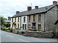
Castle Green houses, Talgarth
This row of 3 houses alongside Bronllys Road (A479) contains numbers 1-3 Castle Green.
Image: © Jaggery
Taken: 14 Aug 2011
0.10 miles
7
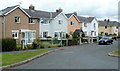
Westfields houses, Talgarth
The houses are on the western side of a grass triangle on a northern spur of Westfields.
Image: © Jaggery
Taken: 14 Aug 2011
0.11 miles
8
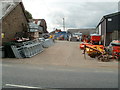
Agricultural engineers' yard, Talgarth
Part of the premises of JC Griffiths & Son, Agricultural Engineers, The Green, Bronllys Road.
Image: © Jaggery
Taken: 14 Aug 2011
0.11 miles
9
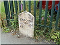
Old milestone, Talgarth
Located alongside Bronllys Road, at the SE corner of the premises of JC Griffiths & Son, Agricultural Engineers. http://www.geograph.org.uk/photo/3011890
Image: © Jaggery
Taken: 14 Aug 2011
0.12 miles
10
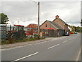
Agricultural engineers' premises, Talgarth
This is the roadside edge of the premises of JC Griffiths & Son, Agricultural Engineers, The Green, Bronllys Road.
Image: © Jaggery
Taken: 14 Aug 2011
0.12 miles