IMAGES TAKEN NEAR TO
Pengenffordd, BRECON, LD3 0EW
Introduction
This page details the photographs taken nearby to Pengenffordd, LD3 0EW by members of the Geograph project.
The Geograph project started in 2005 with the aim of publishing, organising and preserving representative images for every square kilometre of Great Britain, Ireland and the Isle of Man.

There are currently over 7.5m images from over14,400 individuals and you can help contribute to the project by visiting https://www.geograph.org.uk
Image Map
Images are licensed for reuse under creativecommons.org/licenses/by-sa/2.0
Notes
- Clicking on the map will re-center to the selected point.
- The higher the marker number, the further away the image location is from the centre of the postcode.
Image Listing (34 Images Found)
Images are licensed for reuse under creativecommons.org/licenses/by-sa/2.0
Image
Details
Distance
1
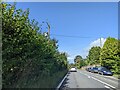
On the A479 in Pengenffordd, heading north
Image: © Rob Purvis
Taken: 29 Sep 2023
0.02 miles
2
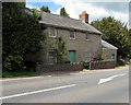
House alongside the A479 in Pengenffordd, Powys
A red King Edward VII postbox https://www.geograph.org.uk/photo/5772588 is in the wall on the right.
Image: © Jaggery
Taken: 13 May 2018
0.02 miles
3
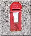
King Edward VII postbox in a Pengenffordd wall, Powys
On the right here. https://www.geograph.org.uk/photo/5772585 The ornate royal cipher dates the box to the reign of King Edward VII who reigned from the death of Queen Victoria aged 81 on January 22nd 1901 until his death on May 6th 1910, aged 68.
Image: © Jaggery
Taken: 13 May 2018
0.02 miles
4
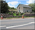
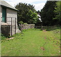
Damaged stone wall on the west side of the A479, Pengenffordd, Powys
In secular use in May 2018, the building is the former Moriah Presbyterian chapel, the 1860 rebuild of the 1835 original.
Image: © Jaggery
Taken: 13 May 2018
0.02 miles
5

A479 next to Moriah Chapel at Pengenffordd
The wall of the graveyard of Moriah Chapel can just be seen on the left of the road. The chapel itself is shown in a 2007 photo by Jonathan Billinger.
Image: © David Gearing
Taken: 12 Aug 2010
0.03 miles
6
Footpath & bridleway descends past the former Moriah Chapel, Pengenffordd, Powys
In May 2018 the former chapel is the premises of PuppetSoup. https://www.geograph.org.uk/photo/5786352
The wooden gate gives access to the A479, the main road through Pengenffordd.
Image: © Jaggery
Taken: 13 May 2018
0.03 miles
7
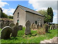
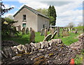
Gravestones and a former chapel in the north of Pengenffordd, Powys
Viewed from the A479 in May 2018. The former Moriah chapel is now the premises of PuppetSoup. https://www.geograph.org.uk/photo/5786352
Image: © Jaggery
Taken: 13 May 2018
0.03 miles
8
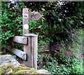
Bridleway direction sign in the north of Pengenffordd, Powys
Located near the wooden gate here. https://www.geograph.org.uk/photo/5786440
The circular sign on the post next to the direction sign shows
BRITISH HORSE SOCIETY LONG DISTANCE ROUTE.
Image: © Jaggery
Taken: 13 May 2018
0.03 miles
9
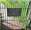
Moriah Chapel - Home to PuppetSoup, Pengenffordd, Powys
The name sign faces the A479 at the entrance to this path. https://www.geograph.org.uk/photo/5786336 The sign states "Please note the Chapel is now Private Property - No Thoroughfare. We at PuppetSoup wish to preserve the heritage and character of the Chapel and its grounds. Access is only permitted for families visiting graves and those visiting PuppetSoup."
Image: © Jaggery
Taken: 13 May 2018
0.03 miles
10
Southeast corner of the former Moriah Presbyterian chapel, Pengenffordd, Powys
The 1860 rebuild of the 1835 original chapel, viewed from the edge of the A479.
In May 2018, the former chapel is the premises of PuppetSoup.
Image: © Jaggery
Taken: 13 May 2018
0.04 miles