IMAGES TAKEN NEAR TO
Regent Street, BRECON, LD3 0DD
Introduction
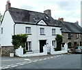
This page details the photographs taken nearby to Regent Street, LD3 0DD by members of the Geograph project.
The Geograph project started in 2005 with the aim of publishing, organising and preserving representative images for every square kilometre of Great Britain, Ireland and the Isle of Man.

There are currently over 7.5m images from over14,400 individuals and you can help contribute to the project by visiting https://www.geograph.org.uk
Image Map
Images are licensed for reuse under creativecommons.org/licenses/by-sa/2.0
Notes
- Clicking on the map will re-center to the selected point.
- The higher the marker number, the further away the image location is from the centre of the postcode.
Image Listing (242 Images Found)
Images are licensed for reuse under creativecommons.org/licenses/by-sa/2.0
Image
Details
Distance
1
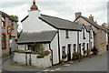
Corner of Regent Street and Heollas, Talgarth
Viewed from Regent Street. A 5' 6" width limit sign on the left is for Heollas. http://www.geograph.org.uk/photo/3297477
Image: © Jaggery
Taken: 14 Aug 2011
0.01 miles
2
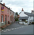
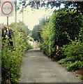
SE end of Heollas, Talgarth
Viewed from Regent Street. The narrow Heollas roadway becomes narrower ahead.
Signs warn of a 5' 6" width limit.
Image: © Jaggery
Taken: 14 Aug 2011
0.02 miles
3
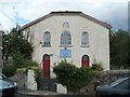
Tabernacle Baptist Chapel, Talgarth
Located in Regent Street. A tablet above the middle window records that the chapel was erected in the year 1837.
Image: © Jaggery
Taken: 14 Aug 2011
0.02 miles
4
Weak bridge, Penbont Road, Talgarth
There is a 3 tonne weight limit on the bridge carrying Penbont Road over the River Ennig.
http://www.geograph.org.uk/photo/3298865 to a side view of the bridge.
Pont Wan on the sign is not the bridge's name. Pont Wan is Welsh for weak bridge.
Image: © Jaggery
Taken: 14 Aug 2011
0.03 miles
5
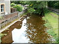
River Ennig viewed from Penbont Road, Talgarth
Viewed from this http://www.geograph.org.uk/photo/3298865 road bridge.
Image: © Jaggery
Taken: 14 Aug 2011
0.04 miles
6
5' 6" maximum width ahead, Heol Las, Talgarth
Already narrow, the roadway narrows further, to 5' 6".
Image: © Jaggery
Taken: 14 Aug 2011
0.04 miles
7
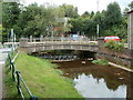
Bridges across the River Ennig, Talgarth
Penbont Road crosses the river. There is a reflection of a footbridge behind the road bridge. At the August 2011 date of this view, scaffolding encased the footbridge, and access across it was blocked.
Image: © Jaggery
Taken: 14 Aug 2011
0.04 miles
8

River Ennig footbridge, Talgarth
The river footbridge consists of planks across scaffolding at the August 2011 date of this view.
The Penbont Road bridge is on the left.
Image: © Jaggery
Taken: 14 Aug 2011
0.04 miles
9
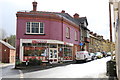
The Strand, Talgarth
Evening Cafe and Restaurant on Regent Street.
Image: © Andrew Abbott
Taken: 14 Mar 2020
0.06 miles
10
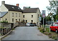
Upper Aberenig House, Talgarth
The Penbont Road house faces the Hospital Road junction.
Image: © Jaggery
Taken: 14 Aug 2011
0.06 miles