IMAGES TAKEN NEAR TO
Llanfaredd, BUILTH WELLS, LD2 3TD
Introduction
This page details the photographs taken nearby to LD2 3TD by members of the Geograph project.
The Geograph project started in 2005 with the aim of publishing, organising and preserving representative images for every square kilometre of Great Britain, Ireland and the Isle of Man.

There are currently over 7.5m images from over14,400 individuals and you can help contribute to the project by visiting https://www.geograph.org.uk
Image Map
Images are licensed for reuse under creativecommons.org/licenses/by-sa/2.0
Notes
- Clicking on the map will re-center to the selected point.
- The higher the marker number, the further away the image location is from the centre of the postcode.
Image Listing (5 Images Found)
Images are licensed for reuse under creativecommons.org/licenses/by-sa/2.0
Image
Details
Distance
2
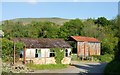
This barn wants out!
Sign is a reference to the up coming EU referendum.
Image: © Anthony Parkes
Taken: 28 May 2016
0.04 miles
3
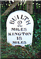
Old Milestone by the A481 east of Llanelwedd
Milestone by the A481, in parish of Llanelwedd (Powys District), about 25m to the East of junction with side road to Newhouse Farm, North side of road.
Inscription reads:-
BUILTH
2
MILES
KINGTON
18
MILES
Grade II listed by Cadw.
Reference Number: 83717 https://cadwpublic-api.azurewebsites.net/reports/listedbuilding/FullReport?lang=&id=83717
Surveyed
Milestone Society National ID: RAD_BUKT02
Image: © Milestone Society
Taken: Unknown
0.05 miles
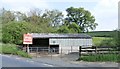
4
Animal shed south of the A481
South of the main road from Builth Wells to New Radnor.
Image: © Jonathan Billinger
Taken: 1 Feb 2008
0.06 miles
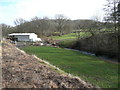
5
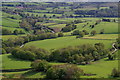
Green fields below Caer Einon
A bird's eye view of farmland towards the River Wye. The Newhouse Farm track and parts of a twisty section of the A481 can be seen.
Image: © Andrew Hill
Taken: 17 May 2018
0.16 miles