IMAGES TAKEN NEAR TO
Builth Road, BUILTH WELLS, LD2 3RP
Introduction
This page details the photographs taken nearby to LD2 3RP by members of the Geograph project.
The Geograph project started in 2005 with the aim of publishing, organising and preserving representative images for every square kilometre of Great Britain, Ireland and the Isle of Man.

There are currently over 7.5m images from over14,400 individuals and you can help contribute to the project by visiting https://www.geograph.org.uk
Image Map
Images are licensed for reuse under creativecommons.org/licenses/by-sa/2.0
Notes
- Clicking on the map will re-center to the selected point.
- The higher the marker number, the further away the image location is from the centre of the postcode.
Image Listing (3 Images Found)
Images are licensed for reuse under creativecommons.org/licenses/by-sa/2.0
Image
Details
Distance
1
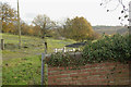
Line of the old railway
With part of the brickwork of the old railway bridge, the line south through Builth Wells to Brecon is just visible (Brecon to Moat Lane railway)
Image: © Phil Jones
Taken: 12 Nov 2008
0.05 miles
2
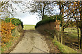
Bridge over the old railway
A bridge over the old Brecon-Moat Lane railway line
Image: © Phil Jones
Taken: 12 Nov 2008
0.08 miles
3
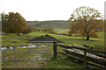
Looking over the Wye Valley
Looking south over the old Brecon-Moat Lane railway line (dismantled) to the Wye Valley and Goytre Wood. What a beautiful railway journey this was.
Image: © Phil Jones
Taken: 12 Nov 2008
0.13 miles