IMAGES TAKEN NEAR TO
Builth Road, BUILTH WELLS, LD2 3RL
Introduction
This page details the photographs taken nearby to LD2 3RL by members of the Geograph project.
The Geograph project started in 2005 with the aim of publishing, organising and preserving representative images for every square kilometre of Great Britain, Ireland and the Isle of Man.

There are currently over 7.5m images from over14,400 individuals and you can help contribute to the project by visiting https://www.geograph.org.uk
Image Map
Images are licensed for reuse under creativecommons.org/licenses/by-sa/2.0
Notes
- Clicking on the map will re-center to the selected point.
- The higher the marker number, the further away the image location is from the centre of the postcode.
Image Listing (56 Images Found)
Images are licensed for reuse under creativecommons.org/licenses/by-sa/2.0
Image
Details
Distance
1
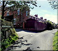
Wye View Terrace, Builth Road
One of two named streets in the hamlet of Builth Road, located around Builth Road railway station on the Heart of Wales Line, about 3km NW of Builth Wells. The other street is Railway Terrace.
Image: © Jaggery
Taken: 1 Sep 2013
0.01 miles
2
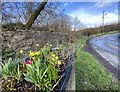
Spring flowers
Roadside spring flowers at Builth Road.
Image: © Alan Hughes
Taken: 1 Mar 2020
0.04 miles
3
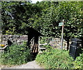
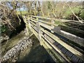
Public footpath from Wye Terrace, Builth Road
The public footpath sign in Wye Terrace points along a wooden footbridge over Dulas Brook, a small tributary of the River Wye. The location is the hamlet of Builth Road, 3km NW of Builth Wells in Powys.
Image: © Jaggery
Taken: 1 Sep 2013
0.04 miles
4
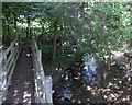
Footbridge over Dulas Brook, Builth Road
The footbridge carries a public footpath over the brook which flows into the River Wye
450 metres SW of this point. Builth Road is a hamlet 3km NW of Builth Wells in Powys.
Image: © Jaggery
Taken: 1 Sep 2013
0.05 miles
5
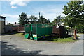
Doubly green recycling skip, Builth Road
The skip is in the hamlet of Builth Road, located around Builth Road railway station on the Heart of Wales Line, about 3km NW of Builth Wells. It is a green skip both in colour and in usage. A notice states that only green recycling (ie green garden waste) is to be put in the skip - no stones or other rubbish. Misuse will result in the facility being taken away
Image: © Jaggery
Taken: 1 Sep 2013
0.05 miles
6
Wooden footbridge
A wooden bridge alongside where there used to be a railway bridge over Nant y Prophwyd at Builth Road.
Image: © Alan Hughes
Taken: 1 Mar 2020
0.05 miles
7
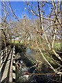
Nant y Prophwyd
Footbridge over Nant y Prophwyd at Builth Road.
Image: © Alan Hughes
Taken: 1 Mar 2020
0.05 miles
8
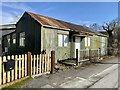
Store building
Corrugated iron storage unit.
Image: © Alan Hughes
Taken: 1 Mar 2020
0.06 miles
9
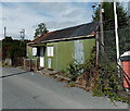
Former shop, Builth Road, Powys
A diagram in a nearby information hut http://www.geograph.org.uk/photo/3632466 shows that this corrugated metal building
used to be a shop. The location is the hamlet of Builth Road, 3km NW of Builth Wells.
The shop is now part of the Cambrian Arms http://www.geograph.org.uk/photo/3631612
Image: © Jaggery
Taken: 1 Sep 2013
0.06 miles
10
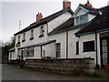
Cambrian Arms, Builth Road
The Cambrian Arms is a pub and shop, about 2 miles north of Builth Wells, near the Builth Road station. They were originally the station buildings for the Cambrian railways mid-Wales line, which is now closed.
Thanks to Dai in exile for this additional information.
Image: © Eirian Evans
Taken: 24 Apr 2006
0.08 miles