IMAGES TAKEN NEAR TO
Llanafanfawr, BUILTH WELLS, LD2 3PH
Introduction
This page details the photographs taken nearby to LD2 3PH by members of the Geograph project.
The Geograph project started in 2005 with the aim of publishing, organising and preserving representative images for every square kilometre of Great Britain, Ireland and the Isle of Man.

There are currently over 7.5m images from over14,400 individuals and you can help contribute to the project by visiting https://www.geograph.org.uk
Image Map
Images are licensed for reuse under creativecommons.org/licenses/by-sa/2.0
Notes
- Clicking on the map will re-center to the selected point.
- The higher the marker number, the further away the image location is from the centre of the postcode.
Image Listing (5 Images Found)
Images are licensed for reuse under creativecommons.org/licenses/by-sa/2.0
Image
Details
Distance
1
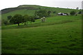
Brongarth and Y Garth
Brongarth is the collection of buildings to the right of centre, Y Garth is the hill in the background. Viewed from the bridleway to the south-east.
Image: © Philip Halling
Taken: 1 Jun 2008
0.01 miles
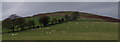
2
Fresh firewood
Ash trees have been cut down from the roadside bank and sawn into logs ready for the fire. An interesting texture has been created in a very plain, green pasture.
Image: © Jonathan Wilkins
Taken: 25 Apr 2011
0.14 miles
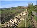
3
Gentle slopes of Y Garth
Sheep grazing land as seen from the lane.
Image: © Andrew Hill
Taken: 28 Oct 2014
0.16 miles
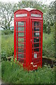
4
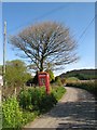
Telephone box with tree
Yes, I know it has been imaged before, but I think it warrants the inclusion of a bit of landscape. An idyllic location by the farm named Awelach (rough translation: more peaceful).
Image: © Jonathan Wilkins
Taken: 25 Apr 2011
0.19 miles
5
Telephone box to the west of Llanafan-fawr
A lonely roadside phonebox near Aweliach to the west of Llanafan-fawr. I do wonder how often these isolated phones are used in this mobile phone age?
Image: © Philip Halling
Taken: 1 Jun 2008
0.20 miles