IMAGES TAKEN NEAR TO
Llanafanfawr, BUILTH WELLS, LD2 3PG
Introduction
This page details the photographs taken nearby to LD2 3PG by members of the Geograph project.
The Geograph project started in 2005 with the aim of publishing, organising and preserving representative images for every square kilometre of Great Britain, Ireland and the Isle of Man.

There are currently over 7.5m images from over14,400 individuals and you can help contribute to the project by visiting https://www.geograph.org.uk
Image Map
Images are licensed for reuse under creativecommons.org/licenses/by-sa/2.0
Notes
- Clicking on the map will re-center to the selected point.
- The higher the marker number, the further away the image location is from the centre of the postcode.
Image Listing (4 Images Found)
Images are licensed for reuse under creativecommons.org/licenses/by-sa/2.0
Image
Details
Distance
2
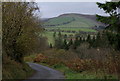
Lane corner near Bwlchciliau
The lane drops steeply to cross the wooded Gwenwst valley. Y Garth on the skyline to the west.
Image: © Andrew Hill
Taken: 28 Oct 2014
0.19 miles
3
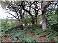
Gweddillion Pen y Rhos / Remains of Pen y Rhos
Gweddillion anhedd-dy o'r enw Pen y Rhos.
The remains of a property known as Pen y Rhos (trans. top of the marshland? / down? /plain?).
Image: © Alan Richards
Taken: 4 Oct 2017
0.22 miles
4
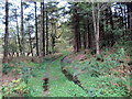
Llwybr ceffyl Pen y Rhos / Pen y Rhos bridleway
Llwybr ceffyl yn mynd i gyfeiriad gweddillion anhedd-dy Pen y Rhos.
A bridleway heading in the direction of the remains of a property known as Pen y Rhos (trans. top of the marshland? / down? / plain?).
Image: © Alan Richards
Taken: 4 Oct 2017
0.23 miles