IMAGES TAKEN NEAR TO
Llanafanfawr, BUILTH WELLS, LD2 3PE
Introduction
This page details the photographs taken nearby to LD2 3PE by members of the Geograph project.
The Geograph project started in 2005 with the aim of publishing, organising and preserving representative images for every square kilometre of Great Britain, Ireland and the Isle of Man.

There are currently over 7.5m images from over14,400 individuals and you can help contribute to the project by visiting https://www.geograph.org.uk
Image Map
Images are licensed for reuse under creativecommons.org/licenses/by-sa/2.0
Notes
- Clicking on the map will re-center to the selected point.
- The higher the marker number, the further away the image location is from the centre of the postcode.
Image Listing (4 Images Found)
Images are licensed for reuse under creativecommons.org/licenses/by-sa/2.0
Image
Details
Distance
1
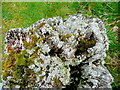
Top of an old gate-post
Colonised by mosses and lichens.
Image: © Jonathan Billinger
Taken: 5 May 2009
0.07 miles
2
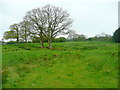
Not-so-rough pasture at Llwyncanol
Image: © Jonathan Billinger
Taken: 5 May 2009
0.08 miles
3
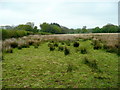
Rough pasture near Llwyncanol
Unimproved land east of the lane.
Image: © Jonathan Billinger
Taken: 5 May 2009
0.13 miles
4
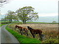
Lane near Llwyncanol; two horses
These animals get the roughest of rough grazing but don't seem too bad on it!
Image: © Jonathan Billinger
Taken: 5 May 2009
0.22 miles