IMAGES TAKEN NEAR TO
Painscastle, BUILTH WELLS, LD2 3JP
Introduction
This page details the photographs taken nearby to LD2 3JP by members of the Geograph project.
The Geograph project started in 2005 with the aim of publishing, organising and preserving representative images for every square kilometre of Great Britain, Ireland and the Isle of Man.

There are currently over 7.5m images from over14,400 individuals and you can help contribute to the project by visiting https://www.geograph.org.uk
Image Map
Images are licensed for reuse under creativecommons.org/licenses/by-sa/2.0
Notes
- Clicking on the map will re-center to the selected point.
- The higher the marker number, the further away the image location is from the centre of the postcode.
Image Listing (4 Images Found)
Images are licensed for reuse under creativecommons.org/licenses/by-sa/2.0
Image
Details
Distance
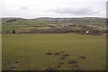
2
Track to The Glyn
A good view north towards the Glascwm Hill plateau (524m).
Image: © Jonathan Billinger
Taken: 2 Feb 2016
0.17 miles
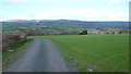
3
Haylage bales
By the drive to The Glyn on the western edge of the Clyro Hill plateau.
Image: © Jonathan Billinger
Taken: 2 Feb 2016
0.18 miles
4
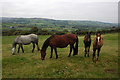
Horses above the Glyn, near Painscastle
The Bachawy flows through the valley in the middle distance.
Image: © Philip Halling
Taken: 6 Oct 2007
0.25 miles