IMAGES TAKEN NEAR TO
Hospital Road, BUILTH WELLS, LD2 3HE
Introduction
This page details the photographs taken nearby to Hospital Road, LD2 3HE by members of the Geograph project.
The Geograph project started in 2005 with the aim of publishing, organising and preserving representative images for every square kilometre of Great Britain, Ireland and the Isle of Man.

There are currently over 7.5m images from over14,400 individuals and you can help contribute to the project by visiting https://www.geograph.org.uk
Image Map
Images are licensed for reuse under creativecommons.org/licenses/by-sa/2.0
Notes
- Clicking on the map will re-center to the selected point.
- The higher the marker number, the further away the image location is from the centre of the postcode.
Image Listing (62 Images Found)
Images are licensed for reuse under creativecommons.org/licenses/by-sa/2.0
Image
Details
Distance
2
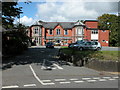
Builth Cottage Hospital
Closed in 2013.
Image: © Chris Andrews
Taken: 21 Jan 2014
0.08 miles
3
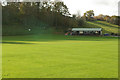
Cricket Field and Pavilion
Builth Cricket field, with the clubhouse/pavilion. During the week the clubhouse provides nursery facilities. The cricket field wood is to the left.
Image: © Phil Jones
Taken: 11 Nov 2008
0.11 miles
4
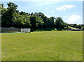
Cricket ground, Builth Wells
Viewed from a gate at the edge of Garth Road. The trees are in Cricketfield Wood.
Image: © Jaggery
Taken: 9 Jun 2013
0.12 miles
5
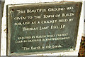
Plaque on the Cricket Field
This plaque gives thanks to Thomas Lant, a local land owner who also gave the Groe and playing fields to the town.
Image: © Phil Jones
Taken: 11 Nov 2008
0.14 miles
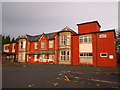
6
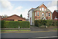
The former doctors surgeries
The old red brick building was a doctors surgery for many years, the single-storey building to the left was a replacement, and still bears marks of the signage on the woodwork. The current custom-built surgery was built further to the west Image
Image: © Phil Jones
Taken: 11 Nov 2008
0.15 miles
7
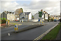
Garth Road Junction
Junction in Garth Road, the A483 splits here, southbound coming from the right, the northbound veers off left through Park Road.
Image: © Phil Jones
Taken: 11 Nov 2008
0.15 miles
8
Distances from Builth Wells
The sign alongside the A483 shows 23 (miles) to Llandovery, 35 to Llandeilo and 50 to Carmarthen. Builth Wells is in Powys which is sparsely populated, as are the mainly rural parts of neighbouring Carmarthenshire through which the road passes.
Image: © Jaggery
Taken: 9 Jun 2013
0.16 miles
9
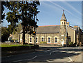
Garth Road Methodist Chapel and Sunday School, Builth Wells
Built in 1895. Further documentation at this http://www.coflein.gov.uk/en/site/12306/details/METHODIST+CHAPEL+%28WESLEYAN%29%2C+GARTH+ROAD%2C+BUILTH+WELLS/.
Image: © Jim Osley
Taken: 23 Apr 2016
0.16 miles
10
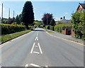
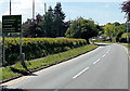
Garth Road west of Park Road, Builth Wells
A view west along the A483 Garth Road. A cricket ground perimeter is on the left. The netting is in place to prevent (most!) cricket balls from leaving the ground.
Image: © Jaggery
Taken: 9 Jun 2013
0.16 miles